
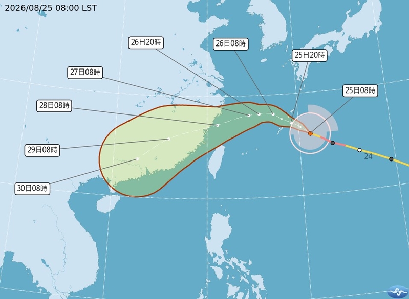
The Central Weather Bureau of Taiwan announced that Typhoon Shadel has weakened to a medium typhoon this morning (25th), and a sea warning may be issued as early as the afternoon of the 26th. Meteorological experts predict that on the 27th and 28th, the center of Typhoon Shadel will pass through the waters north of Taiwan, sweeping over northern Taiwan with strong winds, and is expected to make landfall near Matsu in Fujian on the evening of the 28th.
As of 8:00 am this morning, the center of Typhoon Shadel was located at 26.0 degrees north latitude and 131.2 degrees east longitude, moving at a speed of 21 kilometers per hour towards the northwest. The central pressure is 945 hPa, with maximum sustained winds near the center at 43 meters per second, and maximum gusts of 53 meters per second. The radius of gale-force winds extends up to 220 kilometers (210 kilometers on the northwest side, 310 kilometers on the northeast side, 180 kilometers on the southwest side, and 180 kilometers on the southeast side), while the radius of storm-force winds is 70 kilometers (70 kilometers on all sides).
Associate Professor Wu Derong from the Department of Atmospheric Sciences at Taiwan Central University, speaking in the “Storm Machine Classroom” column of the Meteorological Application Promotion Foundation, stated that according to the latest information from the Central Weather Bureau, Typhoon Shadel (Typhoon No. 18) continues to move northwestward, passing near the Ryukyu Islands on the 26th, gradually turning westward, and then southwestward on the 27th and 28th. The center is expected to enter the waters north of Taiwan, affecting northern Taiwan with strong winds before making landfall near Matsu in Fujian on the evening of the 28th.
Wu Derong mentioned that this morning, Shadel entered an area with reduced oceanic heat content, causing it to weaken from a severe typhoon to a medium typhoon. Although it is expected to continue weakening slowly, the threat to Taiwan remains significant, and people should not underestimate its impact.
He further explained that according to the latest European model ensemble, Typhoon Shadel’s simulated average path indicates that on the 27th and 28th, the center will pass through the waters north of Taiwan, with a slight northward adjustment in the models reducing the probability of the center making direct landfall in Taiwan. While the threat to land has decreased, caution is still advised, and monitoring of model adjustments for timely typhoon preparedness is recommended.
Moreover, he mentioned that Tropical Storm Purple Tan (Typhoon No. 19) is lingering and circling in the southeast of Hanoi, while Tropical Storm Lightning (Typhoon No. 20) in the eastern Philippine Sea is moving counterclockwise along a large low-pressure circulation.
Wu Derong stated that based on the latest European model simulation, starting from today, the southwestern wind will decrease in moisture content, resulting in a reduction in rainfall intensity. However, localized strong convective activities are still expected, and vigilance against severe weather such as thunderstorms, strong winds, and sudden heavy rainfall should be maintained.
He pointed out that the weather will slightly improve during the day on the 26th and 27th, with daytime temperatures gradually rising. There is still a chance of brief rainfall in some areas, particularly in the afternoon. Northern and northeastern regions will experience weather changes influenced by the circulation of Typhoon Shadel on the evening of the 27th, and localized rainfall may also occur in the central and southern mountainous areas on the 28th, with northern Taiwan facing the greatest threat. Weather conditions are expected to improve on the 29th and 30th, with temperatures rising, and localized thunderstorms in the afternoon.