
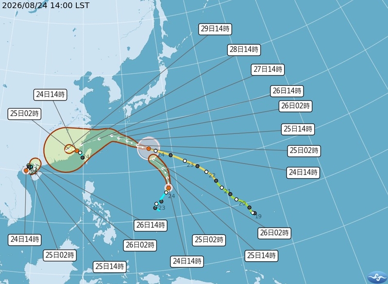
Taiwan’s Central Weather Bureau announced today (August 24th) that Typhoon Shader continues to move towards Taiwan, with a possible sea warning to be issued as early as the 26th. Meteorological experts state that Typhoon Shader is expected to approach the waters near Taiwan’s northern region on the 27th and 28th, with its eyewall sweeping across much of Taiwan and potentially making landfall in Fujian Province on the evening of the 28th.
Forecaster Yeh Chih-chun from Taiwan’s Central Weather Bureau stated today that Typhoon Shader is forecasted to arrive near the Ryukyu Islands on the 26th and then turn southwest towards Taiwan on the 27th and 28th when it will be closest to the island. Based on the current projected path, there is a chance of a maritime typhoon warning being issued on the 26th along with an increasing trend of rainfall in the northern region. However, the exact proximity of the typhoon to Taiwan still needs to be continuously monitored.
The Central Weather Bureau reported that as of 2 p.m. on the 24th, Typhoon Shader’s center was located at 24.5 degrees north latitude and 134.8 degrees east longitude, moving at a speed of 24 kilometers per hour in a west-northwesterly direction. With a central air pressure of 925 hectopascals, the maximum sustained wind speed near the center was 51 meters per second, with gusts of up to 63 meters per second. The radius of strong winds averaged 250 kilometers (260 kilometers to the northwest, 280 kilometers to the northeast, 220 kilometers to the southwest, and 250 kilometers to the southeast), while the radius of gale-force winds averaged 110 kilometers (120 kilometers to the northwest, 120 kilometers to the northeast, 100 kilometers to the southwest, and 110 kilometers to the southeast).
Associate Professor Wu Derong from the Department of Atmospheric Sciences at National Central University of Taiwan mentioned in the “Sky Machine Classroom” column of the Meteorological Application Promotion Foundation that the latest update from the Central Weather Bureau indicates that Typhoon Shader, the 18th typhoon of the season, is currently located in the waters northwest of Guam, moving west-northwest. It is expected to gradually turn towards the west as it passes near the Ryukyu Islands on the 26th, and then head southwest towards the waters off the northern coast of Taiwan on the 27th and 28th, with its eyewall affecting most of Taiwan before potentially making landfall in Fujian on the evening of the 28th.
Wu pointed out that starting from the 25th, Typhoon Shader will enter an area with reduced oceanic heat content, causing it to weaken slowly but still pose a threat to Taiwan as a medium typhoon. Tropical Depression TD24 is situated in the central Taiwan Strait, moving slowly northwestward.
Earlier today, the Central Weather Bureau issued a typhoon formation message, indicating that a tropical depression originating from the waters northwest of Yap Island has developed into this year’s 20th typhoon named Shader, expected to move northeastward with no direct impact on Taiwan.
Wu further mentioned that the latest European model simulations suggest that over the next two days, low-pressure systems will slowly move northward, with southwestern winds bringing moisture across Taiwan. The southwestern and southeastern regions will experience the greatest impact today and on the 25th, with sporadic intense convective activities and localized heavy rain expanding to other areas in the afternoons. People should be prepared for severe weather conditions such as thunderstorms, strong winds, and heavy rainfall over the coming days.
Additionally, Wu stated that the weather may slightly improve on the 26th with daytime temperatures rising, but some areas may still experience brief showers. On the 27th and 28th, the weather is expected to deteriorate due to the typhoon’s influence, although the distribution of wind and rain across different regions will be closely tied to Shader’s path, with models still undergoing adjustments requiring continuous monitoring.
Wu added that according to the latest European ensemble model simulations, the chances of Typhoon Shader passing over the waters off the northern coast of Taiwan on the 27th and 28th have decreased, reducing the likelihood of direct landfall on the island, although it cannot be completely ruled out.