
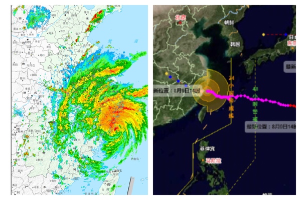
On August 9, 2026, the 13th typhoon of the year, named “White Dolphin,” has made landfall twice in Zhejiang Province, China. At around 5:30 p.m. on August 9, “White Dolphin” landed along the coast of Yuhuan in Taizhou, Zhejiang, and 70 minutes later, it made a second landfall in Leqing, Zhejiang.
Upon its initial landing in Yuhuan, Taizhou, at around 5:30 p.m. on August 9, “White Dolphin” had maximum wind speeds near the center of 14 on the Beaufort scale (42 meters per second) and a minimum central pressure of 945 hPa. After landing, the typhoon continued its westward movement.
Around 6:40 p.m., the center of “White Dolphin” made its second landing along the coast of Wengyong in Leqing, Wenzhou, with maximum wind speeds near the center of 13 on the Beaufort scale (38 m/s) and a central minimum pressure of 950 hPa.
It is reported that “White Dolphin” is one of the typhoons to have made landfall in China since 1951, with its formation position being the farthest east and the longest distance of impact.
Before the landing of “White Dolphin,” strong winds and heavy rain were already affecting the national highway from Leqing, Wenzhou, to Yuhuan, Taizhou. Trees along the roadsides were scattered with branches blown by strong winds, and greenhouse films in the farmland were lifted. Few people were seen on the roads, with sporadic vehicles passing by. Some individuals parked their cars inside tunnels to seek shelter from the storm.
On July 11, Typhoon “Bavi,” the 9th of the year, also made landfall in Yuhuan. A resident named Di Deqing expressed that compared to “Bavi,” the impact of “White Dolphin” was greater in the area, making it difficult even to stand in the wind and rain.
Following its landfall, “White Dolphin” is expected to trigger widespread rainfall. Fang Chong, the chief forecaster at the China Meteorological Administration, stated that from the 11th to the 12th, as the remnants of “White Dolphin” move northward, they will linger near the border areas of Henan, Hubei, and Anhui, bringing significant precipitation to the Beijing-Tianjin-Hebei region. He predicted heavy rain, with some areas experiencing severe and even extremely heavy rainfall.
On August 9 at 6 p.m., the Chinese Ministry of Water Resources and the Meteorological Administration jointly issued a red alert for mountainous flood disasters. From 8 p.m. on August 9 to 8 p.m. on August 10, there is a high possibility of mountainous flood disasters in parts of Zhejiang, southern and western Anhui, and other areas (orange alert), with a very high possibility of such disasters in certain areas of eastern and southern Zhejiang (red alert).
Despite the typhoon making landfall, its impact with strong winds and heavy rain is far from over. According to reports, the National Marine Forecasting Center continued to issue red alerts for high waves and storm surges. From the afternoon of August 9 to the afternoon of August 10, the East China Sea is expected to experience waves and surges ranging from 7 to 12 meters, with the nearshore waters of Zhejiang facing waves between 5 to 8 meters. The alert level for the nearshore waters is red.