
A powerful earthquake struck the waters near Mindanao, in the southern Philippines, on Monday morning (June 8th), with multiple seismic monitoring agencies measuring the magnitude between 7.8 and 8.2. Following the earthquake, the Japan Meteorological Agency issued a tsunami warning, and the government of New Zealand initiated a tsunami risk assessment. As of now, no major disasters or reports of casualties have been reported.
According to reports from the Associated Press, data from the United States Geological Survey (USGS) showed that the earthquake occurred around 7:37 am local time, with its epicenter located approximately 25 kilometers southwest of Burias in southern Philippines, at a depth of about 35 kilometers, with a magnitude of 7.8.
The New Zealand National Emergency Management Agency (NEMA) quoted preliminary monitoring data stating that the earthquake reached a magnitude of 8.2, with a depth of the epicenter ranging between 10 to 63 kilometers. Discrepancies in magnitude during the initial phase of the earthquake are common due to different monitoring data and calculation methods used by various agencies.
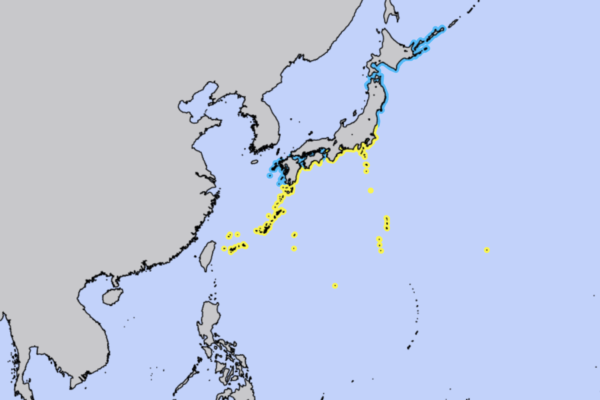
After the earthquake, the Japan Meteorological Agency issued a tsunami warning for a wide coastal area from Kanto to Okinawa, with the highest expected tsunami height reaching up to 1 meter. The affected areas include extensive coastal regions from Kanto to Okinawa in Japan, with tsunami waves expected to occur gradually from midday local time.
The Japan Meteorological Agency reminded the public that tsunami waves may repeatedly reach coastal areas, and until the tsunami warning is lifted, people should stay away from coastal and river areas, refrain from going into the sea or approaching the shore. Even if the tsunami height is not significant, strong sea currents could pose safety risks.
The New Zealand National Emergency Management Agency stated that they are currently assessing with GNS Science, a New Zealand earth science research organization, whether the earthquake could trigger a tsunami that might affect New Zealand. Authorities emphasized that even in the event of a distant tsunami, it would take approximately 10 hours for the waves to reach New Zealand, allowing time for continued analysis of monitoring data and issuance of further alerts.
The Philippines is situated on the Pacific Ring of Fire, where multiple tectonic plate boundaries converge, making it one of the most seismically and volcanically active countries globally. Being in the path of the Northwest Pacific typhoon belt, the Philippines faces the constant threat of earthquakes, volcanic eruptions, and typhoons, with an average of about 20 tropical cyclones entering the Philippine Area of Responsibility each year.
As of now, Philippine officials have not released significant disaster information, and relevant authorities are continuously assessing the impact of the earthquake and tsunami risk.