
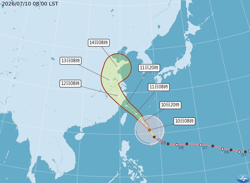
Typhoon “Bavi” struck mainland China as the strongest storm of the year, bringing heavy rainfall to the eastern coastal areas on Sunday, July 12th. The storm also swept through densely populated cities with fierce winds. As a result, thousands of flights and train services in China were canceled, and over 2.4 million people were evacuated from the storm’s path.
At its widest, Typhoon “Bavi” reached 1000 kilometers (approximately 600 miles), equivalent to the width of mainland France. It made landfall in the coastal city of Taizhou, Zhejiang, on Saturday night at 11:12 pm, and landed again around midnight in Wenzhou. The maximum sustained wind speed near its center was about 108 to 117 kilometers per hour (67 to 72 miles per hour).
Although “Bavi” weakened to a tropical storm as it moved inland on Sunday morning local time, meteorologists warned that this storm system, the size of France, could continue to bring sustained and widespread rainfall to eastern and northern China in the coming days.
“When it landed last night, the wind was very strong,” said resident Li Liangxing from Leqing to Reuters. “We could hear the sound of roof tiles and tree branches falling. We were afraid, but living by the sea, we are used to it.”
Pointing to a swollen river next to his residential area, Li said he had never seen the water levels rise so high before. “There used to be a walking path there, but now it’s submerged in water,” he said.
According to CCTV, more than 1300 trees were toppled in Leqing, with over 700 uprooted. The deepest flood reached about half the height of a car tire. In the northern mountainous area of the city, TV footage showed landslides and huge rocks rolling onto mountain roads, with the swollen river submerging nearby trees.
The storm also disrupted transportation networks in mainland China. According to Xinhua, as of 8:00 pm local time on Saturday, Chinese airlines were expected to cancel over 2800 flights.
Airport authorities stated that Shanghai Pudong and Hongqiao airports planned to cancel over 650 flights, accounting for about 30% of their total capacity.
In Hangzhou, two major train stations suspended all operations. Xiaoshan Airport also canceled 296 flights on Sunday, with plans to resume flights after midday as the impact of “Bavi” weakened.
The China Meteorological Administration issued a warning on Saturday evening, stating that some parts of southern Anhui could receive 250 to 350 millimeters (10 to 14 inches) of rainfall within 24 hours, with many areas in Anhui, Zhejiang, Jiangxi, and Fujian provinces expected to experience heavy rain.
It is projected that high-speed winds up to 100 kilometers per hour will occur in parts of the East China Sea, Zhejiang, Shanghai, and southern Jiangsu coastal areas, with gusts reaching force 12 (over 118 kilometers per hour). Zhejiang province has evacuated over 2.2 million people, Fujian province nearly 200,000 people, and thousands have been evacuated in neighboring provinces and Shanghai.
Benjamin Horton, Director of the Energy and Environment Institute at City University of Hong Kong, told Reuters that as “Bavi” continues to move inland in China, areas near the storm’s path could experience several hundred millimeters of rain in the next few days, increasing the risks of flooding, landslides, and urban inundation.
He stated, “Even after the storm weakens upon landfall, its vast circulation could still trigger destructive weather hundreds of kilometers inland.”
Heavy rainfall is expected to persist in Fujian, Zhejiang, Jiangxi, Anhui, Jiangsu, Shandong, and parts of northeastern China until July 14th, with the meteorological department warning of a heightened risk of rain-related disasters. Strong winds may also impact maritime transport, offshore operations, and aquaculture activities along the eastern coast of China.
Scientists caution that with the predicted occurrence of the El Niño weather pattern, China may face more extreme weather this year, with rising temperatures leading to typhoons shifting westward towards the coastal regions.
Horton emphasized, “The rapid intensification of the storm has shortened the preparation time for communities and emergency management personnel, making it more challenging to respond to such events.”