
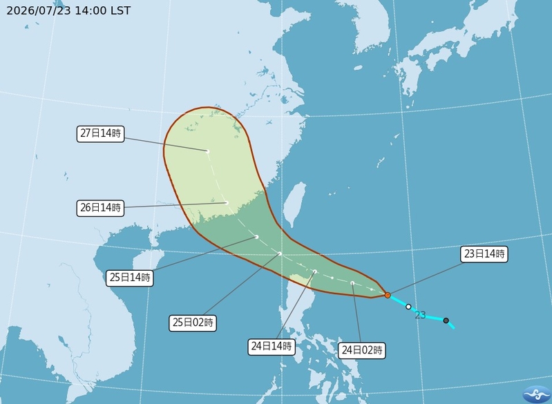
According to Taiwanese meteorological experts today (July 23rd), Typhoon “Hongxia” is expected to form tomorrow (Friday, the 24th) and move in a northwesterly direction. It is predicted to pass through the Bashi Channel from the afternoon of the 24th to the 25th, with strong winds affecting the southern waters of Taiwan. Taiwan will be influenced by the outer cloud bands of Typhoon “Hongxia”, leading to an expanding range of rainfall.
The Central Weather Bureau of Taiwan issued a strong wind advisory (yellow) today, indicating the likelihood of average winds of scale 6 or higher, and gusts of scale 8 or higher in certain areas of Keelung City, New Taipei City, Taoyuan City, Kaohsiung City, Pingtung County, Taitung County (including Orchid Island and Green Island), and parts of Lienchiang County, due to the influence of tropical low pressure or the outer circulation of the typhoon.
Associate Professor Wu Derong from the Department of Atmospheric Sciences at National Central University in Taiwan mentioned in the “Weather Classroom” column of the Meteorological Applications Promotion Fund that based on the Central Weather Bureau’s “Path Potential Prediction Chart”, the tropical low pressure is expected to develop into a mild typhoon, “Hongxia”, on the morning of the 24th.
Wu Derong indicated that the path is projected to continue in a northwesterly direction and pass through the Bashi Channel from the afternoon of the 24th to the 25th, affecting the southern waters of Taiwan, before making landfall in the vicinity of Guangdong early on the 26th. The latest European (ECMWF) model ensemble simulation average path also reflects a similar forecast.
He mentioned that the red frame on the “Path Potential Prediction Chart” and the distribution of individual members both indicate the “uncertainty” of the predicted path. It is important to closely monitor possible adjustments and changes in the degree of impact.
Wu Derong pointed out that the latest model simulations show a significant increase in rainfall probability in the eastern half starting from the evening of the 24th. On the 25th and 26th, the outer cloud bands of Typhoon “Hongxia” will cause a gradual expansion of the rainfall area, with attention needed in the east, southeast, and south for heavy rain, sporadic showers in the central regions, minimal impact in the north, and daytime temperatures remaining relatively high.
“On the 27th and 28th, with southerly winds and residual moisture from ‘Hongxia’, there will be localized rainfall in the southeast and south. Afternoon thunderstorms should be expected everywhere before the rainfall, with hot weather prevailing. On the 29th and 30th, as moisture decreases and the Pacific high pressure slightly strengthens, clear skies and hot weather will be seen across the region, with a chance of localized thunderstorms in mountainous areas in the afternoon,” Wu Derong added.