
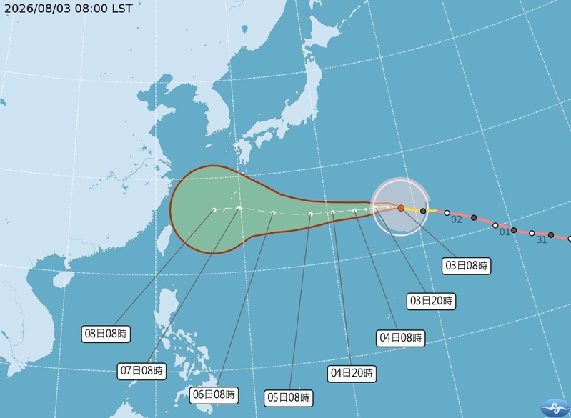
In Taiwan, meteorologists have stated that the large-scale tropical storm Dolphin is expected to move towards the Ryukyu Islands in the next 5 days. The uncertainty of its later path has increased, with a probability of about 40% of affecting the northern sea areas and potentially impacting Taiwan from the 7th onwards.
According to the Central Weather Bureau of Taiwan, as of 8 a.m. today (3rd), the center of the typhoon Dolphin was located at 24.3 degrees north latitude, 148.4 degrees east longitude, moving at a speed of 25 kilometers per hour towards the northwest. The central pressure is 945 hPa, with maximum sustained winds near the center at 43 meters per second, and maximum gusts reaching 53 meters per second. The radius of strong winds at Beaufort scale 7 is 320 kilometers (360 kilometers on the northwest side, 360 kilometers on the northeast side, 270 kilometers on the southwest side, and 290 kilometers on the southeast side), while at Beaufort scale 10, the radius is 160 kilometers (170 kilometers on the northwest side, 170 kilometers on the northeast side, 140 kilometers on the southwest side, and 140 kilometers on the southeast side).
Dr. Wu Derong, an associate professor at the Department of Atmospheric Sciences at National Central University in Taiwan, mentioned in the “Weather Classroom” column of the Meteorological Applications and Development Foundation that Dolphin is slowly weakening but still maintaining its status as a large-scale tropical storm. It is expected to gradually turn northwestward and then westward in the next 5 days towards the vicinity of the Ryukyu Islands.
Dr. Wu stated that the latest European model simulations show that after 5 days, the simulated path becomes more uncertain and divergent. The “Typhoon Range Invasion Probability Chart” for the next 10 days indicates that the average simulated path will pass through the southern East China Sea and then make landfall in Zhejiang, with a probability of the storm affecting the southern East China Sea at around 50%, the northern sea areas of Taiwan at about 40%, and the land areas at around 20%.
He added that the latest simulations after 5 days show an increased uncertainty in the path of Dolphin, but as it remains a large-scale tropical storm and adjusts its course, its threat should still be closely monitored.
Dr. Wu further mentioned that according to the latest European model simulations, today and tomorrow will be influenced by the high pressure in the Pacific Ocean, leading to stable weather conditions. As it is peak summer, it will be hot and sunny across Taiwan, requiring precautions against sunburn and heatstroke, with occasional localized showers expected in the afternoon in the mountainous regions of central and southern Taiwan. The highest temperature across Taiwan today is expected to reach around 38 degrees Celsius.
“On the 5th and 6th, Taiwan will experience northeast winds, bringing brief showers to the windward side of the northern coast and sporadic thunderstorms in the afternoon in the mountainous regions, affecting some parts of the plains. From the 7th to the 9th, Dolphin’s circulation will pass through the northern sea areas towards China, affecting northern Taiwan with brief showers on the 7th, followed by localized showers in the western regions on the 8th and 9th. The temperatures in the northern and eastern regions will be higher, with increased wind speeds across various areas,” Dr. Wu elucidated.
He also mentioned that from the 10th to the 12th, as the typhoon moves away, Taiwan will be affected by southwest winds, resulting in brief showers in the southwest-facing areas and partly cloudy skies in other regions. However, due to unstable atmospheric conditions, localized thunderstorms can be expected in the afternoon.