
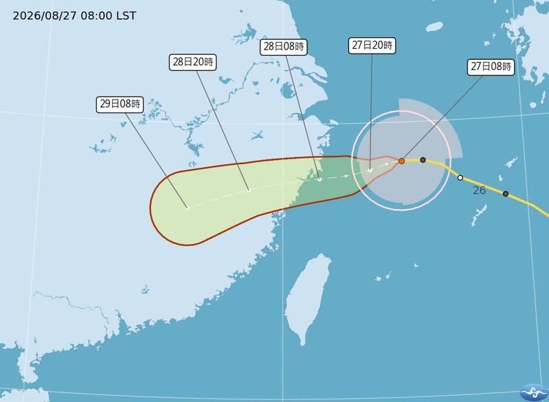
Taiwan’s Central Weather Bureau issued a sea typhoon warning for Typhoon Shader at 8:30 am today (27th), with the typhoon expected to be closest to Taiwan on the 28th. Meteorological experts have predicted that Shader will make landfall in Zhejiang, China on the 28th.
As of 8 a.m. today, the center of Typhoon Shader was located at 28.6 degrees north latitude and 124.9 degrees east longitude, moving at a speed of 10 kilometers per hour in a southwest direction. With a central pressure of 965 hPa, the maximum wind speed near the center is 35 meters per second, and the maximum gusts reaching 45 meters per second. The radius of gale-force winds averages 200 kilometers (180 kilometers to the northwest, 250 kilometers to the northeast, 170 kilometers to the southwest, and 180 kilometers to the southeast), while the radius of storm-force winds averages 60 kilometers (50 kilometers to the northwest, 70 kilometers to the northeast, 50 kilometers to the southwest, and 50 kilometers to the southeast).
The Central Weather Bureau of Taiwan stated on the 25th that Typhoon Shader had weakened to a severe tropical storm in the morning, with the sea warning expected to be issued in the latter half of the 26th. Meteorological experts predict that on the 27th and 28th, the center of Typhoon Shader will pass through the waters north of Taiwan, affecting northern Taiwan with gale-force winds before making landfall near Matsu and Fujian on the evening of the 28th.
Associate Professor Wu Derong from the Department of Atmospheric Sciences at National Central University of Taiwan mentioned in the “Sky Machine Classroom” column of the Meteorological Application and Promotion Foundation today that Typhoon Shader is expected to gradually weaken to a tropical storm, with the gale-force winds diminishing gradually. The typhoon will move westward and then southwestward, passing through the southern East China Sea, with its outer periphery affecting the waters north of Taiwan, posing a slight threat. The typhoon is expected to make landfall in Zhejiang on the morning of the 28th.
Wu Derong pointed out that the southern and northern parts of Taiwan will experience different weather conditions today and on the 28th, with the southwest receiving localized rainfall and afternoon convection leading to an expansion of the precipitation area. In the north, there will be periods of clear skies with occasional light rain, and daytime temperatures gradually rising. On the 29th and 30th, the south will experience localized rainfall with unstable atmospheric conditions, leading to strong convective activity in the mountains in the afternoon, affecting some plains with thunderstorms, strong winds, and heavy rainfall.
He also cautioned that next week the season’s trough will be active, and there are signs of tropical disturbances developing in the seas to the east of Taiwan and in the South China Sea, potentially interfering with each other’s trajectories. As a result, simulations from physical or AI models of different countries show significant differences, leading to a high degree of uncertainty and instability in next week’s weather. It is premature to draw conclusions, so continuous monitoring is necessary.