
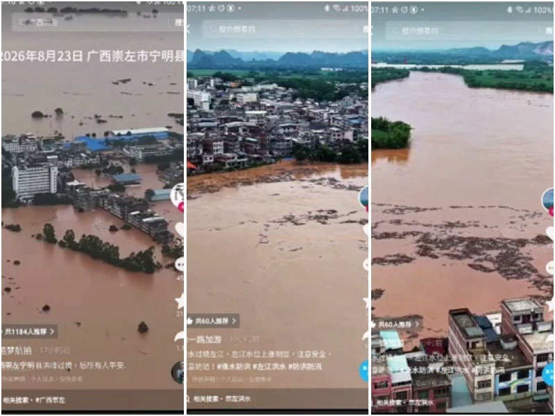
Recently, several areas in Guangxi, including Chongzuo, Ningming, Longzhou, Pingxiang, and Shangsi in Fangchenggang City, have been hit by a new round of flooding due to the impact of Typhoon “Zitan.” In Ningming County, the flood peak reached 123.5 meters, the highest water level since 2008 when the town was submerged.
Since August 21, continuous heavy rainfall has been affecting southwestern and coastal areas of Guangxi due to Typhoon “Zitan” and its peripheral circulation. Within just over a month, severe basin-wide floods have reemerged.
From 8 a.m. on the 22nd to 8 a.m. on the 23rd, tributaries such as left Jiang, Mingjiang, and Heishui River have risen by 4 to 11 meters, with 13 rivers and 19 hydrological stations experiencing floods exceeding the safety levels, with the highest exceeding by 6.03 meters. Ningming County in Paleyin River witnessed the second-largest flood since the station was established in 2014.
By 6:50 a.m. on the 23rd, the Chongzuo station of the left Jiang River reached the warning water level and was officially designated as “Flood No. 1 of 2026.” As of 6 p.m. on the 23rd, official reports stated that this disaster has affected 61,000 people, with 54,000 relocated and 8,087 accommodated.
The severely affected areas mainly include Ningming, Longzhou, Jiangzhou, Fuzui in Chongzuo City, and Shangsi in Fangchenggang City. Ningming County town has been submerged, with videos online showing ground floors of some buildings almost entirely underwater, leaving only the store signs visible; in other areas, only rooftops and treetops are visible above the water.
Ms. He, a resident of Nakan Town, stated in an interview with Jupai News that the water level in her home reached 3 meters deep, forcing them to seek refuge on the second floor. Her house operates a clinic on the street, and water started entering from 1 a.m. on the 23rd, only managing to relocate medical supplies stored on the first floor.
Ms. He mentioned facing challenges post-disaster, including water, power, and internet outages, inability to contact her family, and immediate needs for drinking water and disinfectants.
On August 24th, the floods continued to rise. The water level at the Ningming County town section of the Ming River reached around 123 meters, nearly 7 meters above the safety level. With significant upstream water inflow and the rise in the Longzhou section of the left Jiang River, the Ming River’s water recession has been slow. It is projected that when the flood peak reaches the county town at 2 a.m. on the 25th, the water level will hit 123.5 meters, exceeding the safety level by 7.5 meters, surpassing the historical record high of 122.62 meters in 2008.
Similarly, in Shangsi County of Fangchenggang City, the river surged, flooding several streets in the county town and inundating residential houses, leading to the relocation of over 3,000 people.
As the floods move towards Longzhou, Jiangzhou, Fuzui, and Nanning and convey along the Yujiang River to Hengzhou and Guigang, the low-lying areas along the river face various risks such as mountain torrents and geological disasters.
On August 24th, locals in Hengzhou confirmed to Epoch Times that water levels were rapidly rising, with the flood peak expected to pass through within two days.
According to the forecast by the Guigang Water Resources Department on August 24th, from August 26th to 29th, the Yujiang and Xunjiang rivers will rise by 2 to 4 meters; the Xunjiang is likely to be named a flooding river; the Guigang urban area is expected to have a peak of about 42.50 meters; with a safety level of 41.20 meters, an excess above this level of about 1.30 meters is predicted, along with local rainfall of 80 to 150 millimeters and over 200 millimeters in some areas.
In early July 2026, due to the impact of Typhoon No. 10 of the year, “Meisake,” six blue, Yunbiao, Liuwang, and Baihe reservoirs, as well as Da Kai, Gandao, Jijing, Lingdong, and Shinuo reservoirs in Guigang, experienced dam failures and breaches, leading to severe flooding and significant casualties in Nanning and Guigang, Guangxi.
It was revealed by the public that the death toll was at least in the four digits, but the local government concealed the death toll. Under domestic and international pressure, the State Council of the Chinese Communist Party was forced to send an investigation team to Guangxi, and as of now, no conclusion has been reached. Recently, the local authorities updated the death toll, adjusting it from 39 to 159, more than four times the previous number.
On August 24th, Xinhua Net published the Guangxi Water Resources Department’s flood control work report, mentioning for the first time the existence of 20 dangerous reservoirs. The report stated, “Further implement defense measures for dangerous reservoirs and mountain flood-prone areas, verify and urge the 20 dangerous reservoirs, require the maintenance of empty reservoir operations, and strengthen measures against typhoons, heavy rains, and floods.”
Currently, the Guangxi Water Resources Department has not disclosed the names and locations of the 20 vulnerable reservoirs mentioned above, nor have they specified if they have been emptied.