
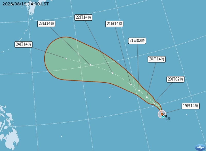
Taiwan’s Central Weather Bureau issued a typhoon alert on the afternoon of August 19 for Typhoon Saudel. Meteorological experts warned of the potential for heavy rainfall from August 20 to 24 as a low-pressure system moves northward. The typhoon Saudel is currently heading towards the Ryukyu Islands with an uncertain path.
According to the Central Weather Bureau, the tropical depression located southeast of Guam developed into a tropical storm at 2 p.m. today, named Typhoon Saudel (international name: SAUDEL), which is the 18th storm of the season.
At 2 p.m. on the 19th, Typhoon Saudel’s center was positioned at 8.2 degrees north latitude, 153.8 degrees east longitude, moving north at a speed of 32 kilometers per hour. The central pressure is 998 hPa, with maximum sustained winds near the center at 18 meters per second and maximum gusts of 25 meters per second. The storm’s radius of 7-level wind is 80 kilometers, with 80 kilometers on each side (northwest, northeast, southwest, southeast).
Dr. Wu Derong, an associate professor at the Department of Atmospheric Sciences at National Central University, mentioned in the weather forecast community column “Xietianji Classroom” that the latest European model simulations indicate an unstable atmosphere today, especially in the eastern region where there is abundant moisture, leading to localized short-term rainfall. In the northern and central/southern regions, strong convective activities may develop in the afternoon and caution should be exercised. The weather remains hot when there is no rainfall.
Dr. Wu further explained that the latest model simulations suggest that from August 20 to 24, the slow northward movement of the low-pressure system, combined with southwest winds carrying moisture over Taiwan, will lead to even more unstable atmosphere, resulting in more pronounced rainfall. Intermittent strong convective activities can occur with accompanying thunderstorms, strong winds, and sudden heavy rain. It is essential to pay attention to short-term weather updates and special weather bulletins during this period, while daytime temperatures may see a slight decrease.
Looking ahead, Dr. Wu forecasted that from August 25 to 28, the Pacific high-pressure system will gradually strengthen, bringing clear and hot weather across the region. People are advised to take precautions against sunburn and heatstroke, while localized afternoon showers in mountainous areas may gradually decrease.
Regarding the trajectory of Typhoon Saudel, Dr. Wu mentioned that over the next 5 days, it is expected to move in a northwesterly direction towards the Ryukyu Islands. The latest European model ensemble simulations suggest that from the 6th to the 10th day, the storm’s intensity will continue to increase, although its forward speed will gradually decrease. The storm might make a northern turn near the Ryukyu Islands; however, due to the significant spread in path projections within the ensemble model simulations, there remains a high level of uncertainty, necessitating further observation.