
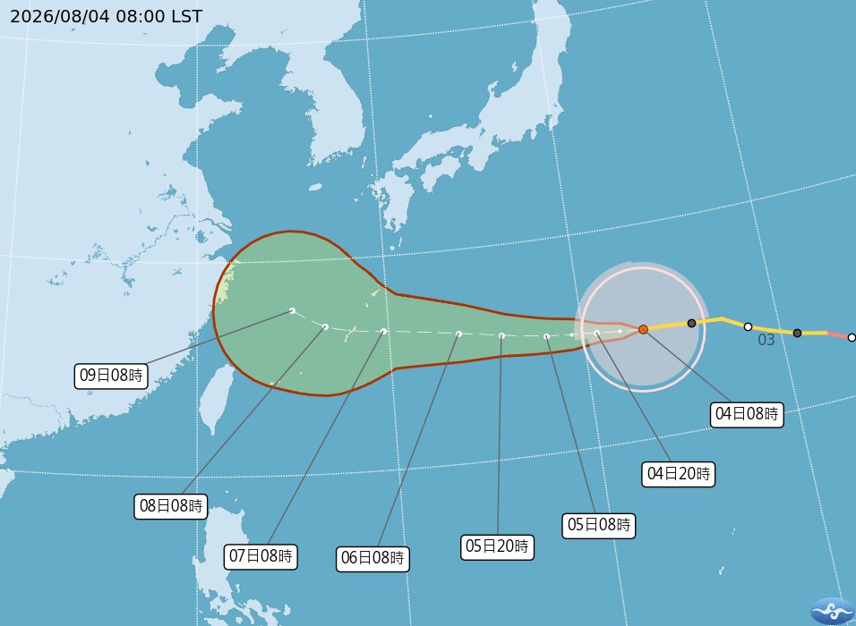
Taiwanese meteorological experts have indicated that the track of Typhoon Baihaidang will resemble scattered flowers, passing over the northern waters of Taiwan from the 7th to the 9th of the month. On the 7th, the weather in northern and central-southern parts is expected to see localized brief showers, while on the 8th and 9th, rainfall will intensify in the western regions, with caution advised for strong gusts of wind.
The Central Weather Bureau of Taiwan reported that as of 8 a.m. today (4th), the center of the typhoon was located at 25.1 degrees north latitude and 143.1 degrees east longitude, moving westward at a speed of 20 kilometers per hour. With a central pressure of 945 hPa, maximum sustained wind speed near the center reaching 43 meters per second, and maximum gusts of 53 meters per second, the radius of gale-force winds extends up to 320 kilometers (360 kilometers on the northwest side, 350 kilometers on the northeast side, 290 kilometers on the southwest side, and 290 kilometers on the southeast side).
Dr. Wu Derong, an associate professor at the Department of Atmospheric Sciences at Taiwan Central University, stated in a column of the Meteorological Application Promotion Foundation’s “Weather Machine Classroom” that Typhoon Baihaidang is gradually weakening but remains a large-scale mid-typhoon. Over the next 4 days, it will continue on a westward trajectory, passing near the Ryukyu Islands before entering the southern East China Sea on the 5th day, gradually turning northwestward with reduced speed and increased uncertainty.
Dr. Wu pointed out that according to the latest European model simulations, variations in the weakening speed of the northern high-pressure system over the next 4 days have led to differences in the westward trend and the intensity of the northward deviation, resulting in a dispersion resembling scattered flowers. The farther northward and larger the angle of deviation, the less the impact on Taiwan, making it a key observation point in the coming days.
Based on the latest European model simulations, Dr. Wu forecasts that today and tomorrow (5th), under the influence of the Pacific high pressure system, stable atmospheric conditions and hot weather are expected throughout the country. Sun protection and heatstroke prevention are advised, with occasional localized showers in mountainous areas of the central and southern regions during the afternoons. On the 6th, a northeast wind will sweep across Taiwan, bringing brief localized showers to the windward northern regions and thunderstorms affecting some low-lying areas during the afternoon.
Dr. Wu further elaborated that from the 7th to the 9th, as Typhoon Baihaidang’s circulation passes over the northern waters of Taiwan towards China, the northern and central-southern regions will experience localized brief showers on the 7th. The 8th and 9th will see increased rainfall and slightly cooler temperatures in the western regions, while the eastern regions may face extreme heat due to downslope winds, prompting caution for strong gusts of wind throughout the country.