
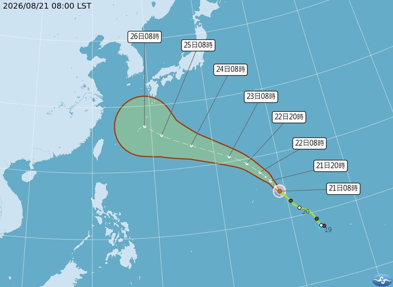
Taiwanese meteorologists have indicated that Typhoon Shadel has the potential to intensify into a severe typhoon. Weather conditions after the 26th will be subject to changes depending on the trajectory of Shadel, necessitating close monitoring. From today (21st) to the 25th, impacted by a low-pressure system and southwest winds, the southwest region will be most affected, posing risks of severe rainfall-induced disasters.
According to the Central Weather Bureau of Taiwan, as of 8 a.m. on the 21st, the central position of Typhoon Shadel was located at 14.2 degrees north latitude and 149.1 degrees east longitude, moving at a speed of 19 kilometers per hour in a north-northwesterly direction. The central pressure was 988 hPa, with the maximum wind speed near the center reaching 23 meters per second and the maximum instantaneous gusts hitting 30 meters per second. The average radius of strong wind force reaching seven on the Beaufort scale was 100 kilometers (northwest side 90 kilometers, northeast side 120 kilometers, southwest side 60 kilometers, southeast side 110 kilometers).
Associate professor Wu Derong of the Department of Atmospheric Sciences at National Central University of Taiwan stated today in the “Sky Machine Classroom” column of the Meteorological Applications Promotion Foundation that the latest Central Weather Bureau’s path potential forecast map shows that Typhoon Shadel No. 18 is located over the waters east of Guam and is projected to move west-northwest to northwest, heading towards the Ryukyu Islands over the next five days with a gradual increase in intensity, potentially developing into a severe typhoon.
Wu Derong mentioned that the latest European Centre for Medium-Range Weather Forecasts (ECMWF) ensemble model indicates that Typhoon Shadel is predicted to continue moving west-northwest at a slower pace starting from the 26th, entering the southern East China Sea. On the 27th and 28th, it is forecasted to make a northeastward turn near the mouth of the Yangtze River, with individual simulation paths diverging on both sides. Due to some simulations showing a weaker projection of the northern high-pressure system, there are fewer cases of early turns, while with a stronger projection, more cases suggest a continuous westward movement, indicating a trend of westward adjustment in the predicted path that requires further observation.
He further cautioned that the latest European model simulations indicate that from today until the 25th, the slow northward movement of the low-pressure band, accompanied by southwest winds carrying moisture over Taiwan, will have the greatest impact on the southwest region. Periodically, there may be developments of strong convective activities or incursions, sometimes expanding to other areas. Attention should be paid to severe weather conditions such as thunderstorms, strong winds, and sudden heavy rains, as well as being vigilant against disasters caused by continuous heavy rainfall.
Wu also stressed that the latest model simulations reveal that the weather changes after the 26th will depend on the trajectory of Typhoon Shadel and its interaction with the surroundings, emphasizing the need for close monitoring and observation.