
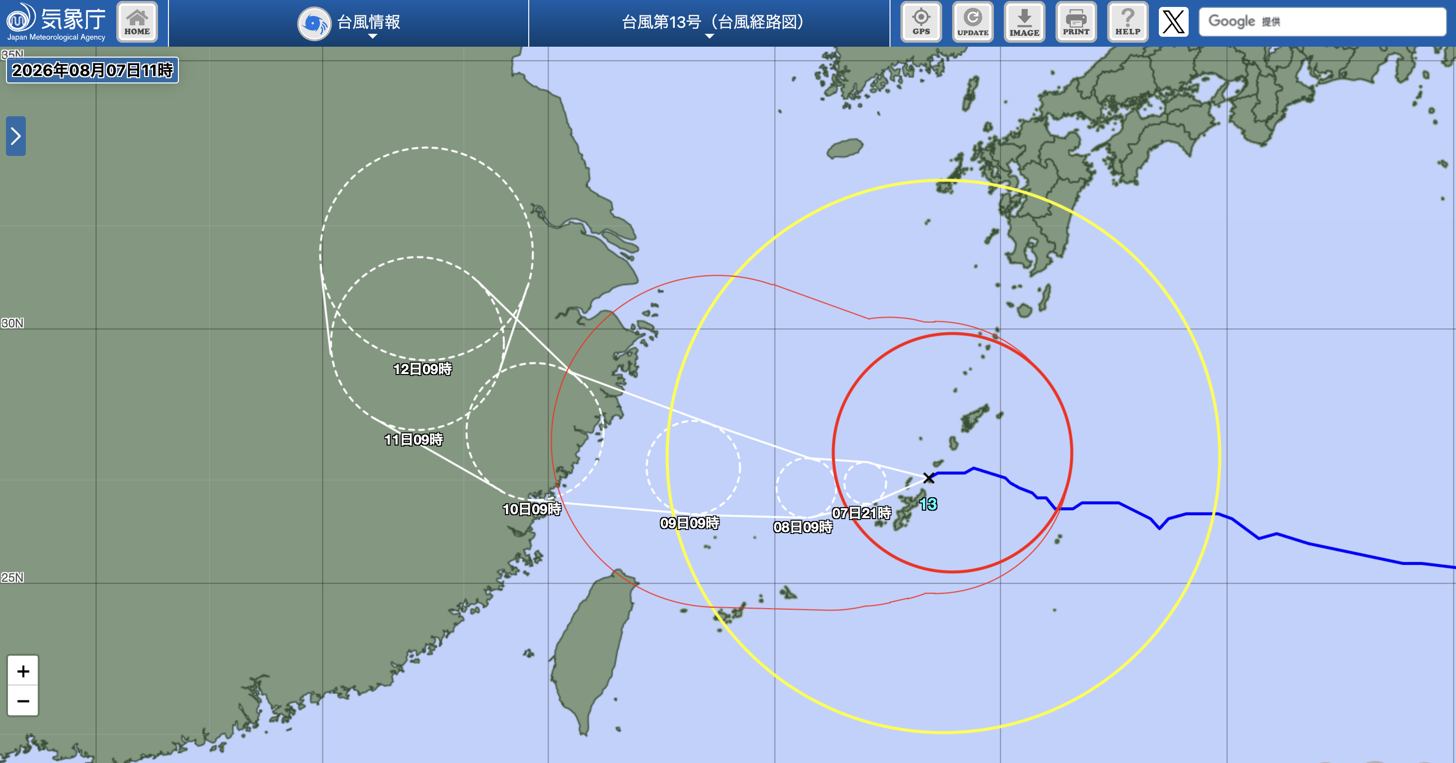
On Friday, August 7th, a large typhoon named “Dolphin” (Typhoon No. 13) approached the Okinawa and Amami regions of Japan, greatly affecting transportation. All 417 flights at the four airports in Okinawa were canceled on that day, with an additional 274 flights scheduled to be grounded from the 8th to the 9th, affecting approximately 105,000 passengers over three days.
According to local media Ryukyu Shimpo, due to the typhoon, the main four bus companies in Okinawa and the Okinawa Urban Monorail (Yui Rail) suspended operations for the entire day on the 7th. The airports in Naha, Miyako, and Ishigaki were closed all day, and although the underground airport briefly opened its counter services, all flights were also canceled.
Furthermore, flight information at Amami Airport on that day showed that most flights to and from Kagoshima, Tokyo (Haneda), Osaka (Itami, Kansai), Fukuoka, Okinawa, and internal island routes were marked as canceled, with only a very small number of flights still operating.
Maritime transportation was also heavily impacted. The Okinawa Passenger Ship Association stated that at least 27 ferries were suspended on the 7th, and the majority of routes between the main island and outlying islands ceased operations. On land, the Okinawa Expressway, Naha Airport Expressway, and several sea-spanning bridges were closed, with several national highways implementing traffic controls, and the restoration time depending on weather conditions.
According to the Japan Meteorological Agency, as of noon on the 7th, the typhoon’s center was located near Tokuno Island, moving westward at a speed of 25 kilometers per hour, with a central pressure of 940 hectopascals. The maximum sustained wind speed near the center was 40 meters per second, with the maximum gust speed reaching 55 meters per second, and it is expected to maintain its intensity as it continues moving west.
Currently, the entire main island of Okinawa has entered the storm circle, with the northern region closest to the center of the typhoon. The central and southern parts are expected to be most affected between 3 p.m. and 6 p.m. on that day. The Meteorological Agency has issued heavy rain warnings for the northern part of Okinawa and storm surge warnings for Kume Island, with both alerts potentially being upgraded.
The meteorological department also warned of a possible “linear rain band” forming in the Okinawa and Amami regions, leading to extremely heavy rainfall in a short period, increasing the risk of floods and landslides. The Meteorological Agency warned that the 24-hour cumulative rainfall in Okinawa, Amami, and southern Kyushu could reach up to 200 millimeters by the morning of the 8th, with localized areas likely to experience severe convective weather such as thunderstorms and tornadoes.
Due to the impact of the typhoon, local governments have issued evacuation orders to approximately 260,000 residents in Kagoshima and Okinawa Prefectures. In particular, about 45,000 households in the Amami region of Kagoshima Prefecture received a Level 4 evacuation order. A Level 4 evacuation order is the second-highest alert level in Japan’s disaster alert system, indicating extremely high disaster risk and requiring residents in dangerous areas to evacuate to safety immediately.
Moreover, the Okinawa Prefectural Government reported that as of 7 a.m. on the 7th, all 34 cities and towns in the prefecture had opened evacuation centers, with 244 people seeking shelter. Additionally, three men in their seventies sustained minor injuries, with two knocked down by strong winds and another injured during disaster preparedness when a chair was blown over.
The Amami region continued to experience power outages, with approximately 20,200 households in towns like Kikai and Amami City experiencing blackouts as of 11 a.m.; Okinawa Island and the Ogasawara Islands also had around 2,250 households without power.
The peripheral circulation of the typhoon already covered much of Kyushu, with Kumamoto Prefecture also experiencing strong winds, where in some areas, the maximum gust speed reached 16.8 meters per second.
Kumamoto had just experienced a magnitude 7.1 earthquake, resulting in many damaged or collapsed houses, with approximately 6,700 residents still in evacuation centers. The Meteorological Agency warned that post-earthquake geological instability coupled with heavy rainfall could heighten the risk of secondary disasters such as landslides, urging residents to remain vigilant.
Simultaneously, the Meteorological Agency warned that high temperatures would persist in some areas, with the maximum temperature possibly reaching 36 degrees Celsius, advising people to be mindful of both typhoon preparedness and heatstroke risks.
Furthermore, the Japan Meteorological Agency stated that Typhoon No. 15 had formed in the waters near Wake Island on the afternoon of August 5th, with no distinct storm circle yet. The typhoon is currently moving north-northeast at a speed of about 15 kilometers per hour and is not expected to significantly intensify, following a trajectory along the eastern sea of Japan, with no direct impact on Japan anticipated in the short term.
(Contributed by Reuters)