
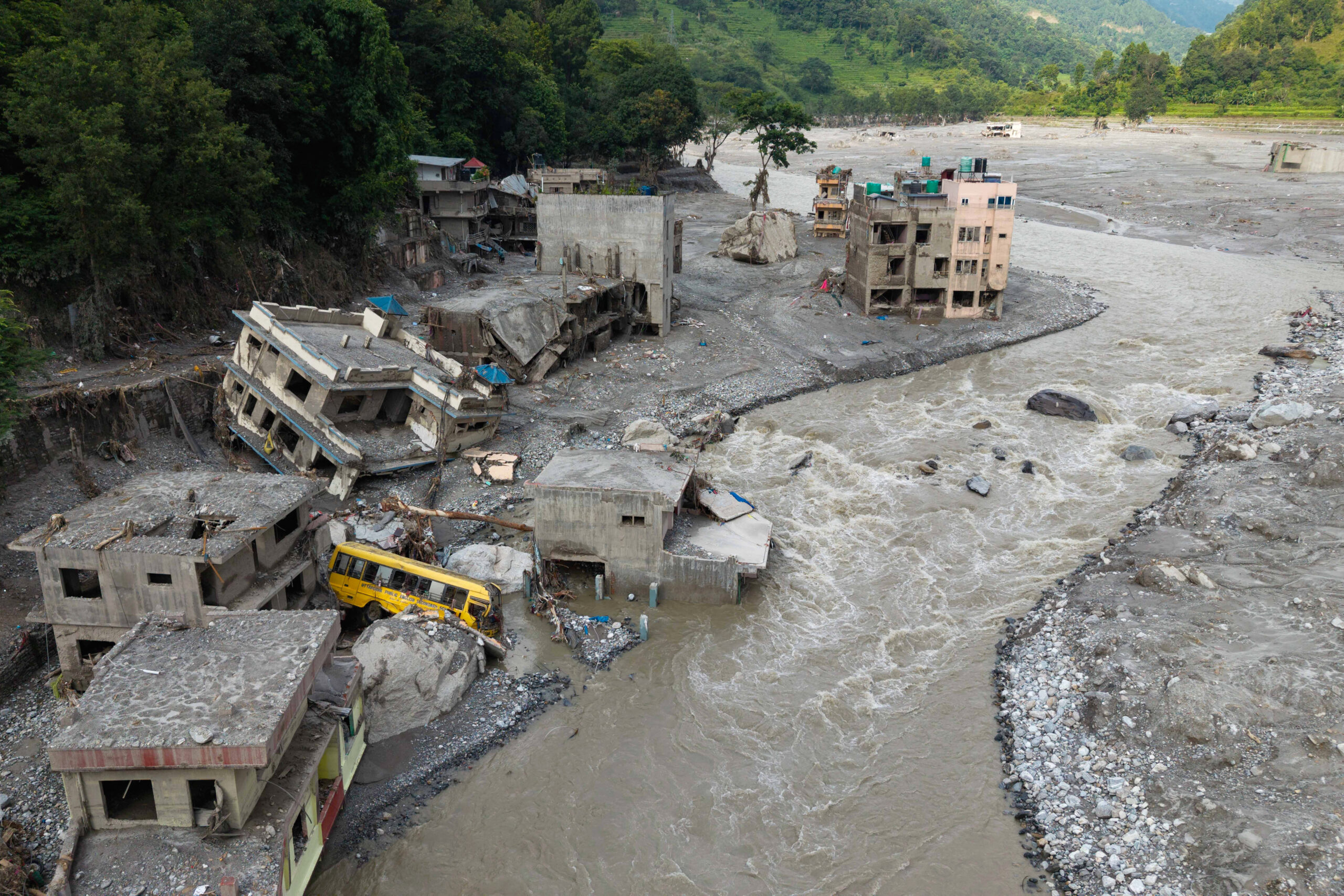
On August 26, a massive mudslide struck the China-Nepal border, engulfing the Gyirong Port in the Shigatse city of Tibet. As of Tuesday (September 1), the death toll has surpassed 1,000 people, with nearly 5,000 individuals still missing. Local rescue efforts are ongoing.
This devastating disaster raises questions about whether the Chinese authorities had the capability to issue advance warnings and why they did not share timely information that should have been shared with Nepal, making the safety risks of the downstream areas of the Yarlung Tsangpo River hydropower project a global focus.
In response to these issues, reporters from “Epoch Times” interviewed water resources expert Wang Weiluo, who currently resides in Germany. He pointed out that scientific reports had long warned of the risks of similar events recurring and that had China shared data early, downstream losses could have been reduced. He also cautioned about the high-altitude geological risks faced by the Yarlung Tsangpo River large-scale hydropower project.
The China-Nepal border region boasts some of the world’s highest peaks, vast glaciers, snowfields, and steep and unstable mountain slopes. Rivers originating from the Qinghai-Tibet Plateau rapidly cascade through deep valleys before flowing towards densely populated areas in Nepal.
Regarding the cause of this disaster, Dr. Basanta Raj Adhikari, a disaster research expert from Tribhuvan University in Nepal, told the BBC that this flash flood was more likely triggered by a glacial collapse leading to an ice-rock avalanche.
Wang Weiluo believes this is a long-term accumulation process that suddenly spiraled out of control, not something that can be simply attributed to a single earthquake or a specific heavy rain event.
He analyzed that glacial collapses are due to the long-term effects of climate change causing glacier instability. Under normal circumstances in nature, glaciers move forward slowly, and some glaciers, such as glacier tongues, can become unstable on rock substrates and fracture.
He added that the 7.8 magnitude earthquake in Nepal in 2015 may have altered the stability of the rock mass beneath the glaciers. Following the earthquake, the region of the Langtang Lirung Peak experienced multiple landslides. Additionally, on August 26 this year, the East Linzangbu River was in the monsoon season, a period of high flow, suggesting the presence of a debris dam before the glacial collapse or at least the existence of a barrier lake.
Wang Weiluo believes that these landslides may have affected the stability of the rock layers beneath the glacier. Therefore, studying not only the changes on the glacier’s surface but also the bedrock beneath is essential.
He emphasized, “The devastating impact of the mudslide disaster on the Gyirong Port is crucial because the terrain at the entrance of the East Linzangbu River into the Gyirong River was altered artificially, narrowing the river and forcing the mudslide to increase in height.”
If the glacial collapse is considered the natural trigger of the disaster, Wang Weiluo believes that another important factor contributing to the severe destruction of the Gyirong Port is the human alteration of the riverbed terrain.
He pointed out that at the entrance of the East Linzangbu River into the Gyirong River, the river was compressed by construction projects, narrowing the riverbed.
This means that when a large amount of mudslide rapidly rushes down from upstream, the floodwaters and mudslides that could have spread to the sides are confined within the narrowed riverbed.
“The result is: the narrower the river becomes, the higher the mudslide will be, and the greater the impact on surrounding facilities.”
Video: On the morning of August 26, a massive mudslide struck the China-Nepal border, swallowing the Gyirong Port instantaneously.
Taiwan artificial intelligence laboratory founder Du Yijin recently wrote on Facebook, “The greatest sin of sentient beings is to mistake man-made disasters for natural disasters. If this had happened in Taiwan, it would not be called a natural disaster.” He pointed out that the Gyirong Port is akin to a large illegal construction on the river, squeezing the flood channel and engaging in a territorial dispute with the river, leading to nature’s backlash and inevitable disaster.
As early as 2018, exiled Tibetan writer Sangye Kyab warned that the Chinese Communist Party had been constructing large-scale reservoirs, hydropower stations, and intensively mining mountains in Tibet for years, becoming a time bomb on the heads of Tibetans.
The downstream Nepal has suffered heavy losses, with the death toll exceeding 1,000 people and nearly 5,000 individuals missing.
Experts suggest that disasters such as landslides, avalanches, and glacial collapses cannot be entirely prevented, but establishing an early warning system can significantly mitigate their impact.
In response to this disaster, a report by Reuters on August 30 highlighted a crucial fact: three months before the disaster, Nepal had already requested cooperation with the Chinese authorities on transboundary glacial disaster monitoring and early warning.
On May 27, officials and experts from China and Nepal held a meeting in Kathmandu. Nepal proposed discussions on enhancing cooperation in monitoring and dealing with floods, weather, and glacier-related disasters; urging joint risk reduction measures, such as jointly investigating glacier lakes and drawing up disaster risk maps.
Binod Parajuli, a hydrology expert from Nepal, recently revealed that the Chinese representatives at the time stated they had not been authorized to sign a cooperation agreement and suggested further negotiations.
The Chinese Foreign Ministry and the Chinese Embassy in Nepal argued that China had timely shared hydrological information and assisted Nepal in disaster prevention.
Nepalese officials stated that similar concerns had been expressed last year during flooding in the same region. At that time, a sudden overflow of a glacial lake in Tibet caused at least nine deaths and more than 10 people missing in Nepal.
Wang Weiluo stated that the Chinese leaders believed that sharing data with others would affect national security. However, this is not the case. Data should be reciprocal.
On August 29, Chinese Foreign Minister Wang Yi phoned Nepalese Foreign Minister Psyllium and said China had shared important information on disaster area images, satellites, hydrology, including early warning information on upstream barrier lakes, with Nepal.
Wang Weiluo speculated that China had not provided data to Nepal before.
Indian strategic scholar, writer, strategic research professor, and former Indian National Security Advisor Brahma Chellaney also pointed out on the social media platform X that Nepal had been actively seeking to formalize bilateral agreements with the Chinese authorities and had hoped to use its framework for water and weather data sharing with India as a reference. Still, China had never established an information-sharing or warning mechanism with any neighboring country.
Wang Weiluo further pointed out that he observed China providing hydrological and meteorological data to neighboring countries with apparent political motives.
He cited the example of China-India relations. When Sino-Indian relations are relatively good and leaders visit each other, China would share relevant data with India; however, data sharing might be affected when bilateral relations are tense.
He believed that a similar scenario could exist between China and Nepal. If Nepal maintains good relations with the Chinese authorities and openly expresses support for China’s stance on Tibet, China might provide Nepal with more relevant data.
“But if the Nepalese government undergoes changes and its policy towards China shifts, data sharing could be affected.”
Wang Weiluo believed that the core issue lies in whether hydrological and meteorological data are disaster prevention data or diplomatic bargaining chips.
“If it is data for disaster prevention, then in the face of transboundary disaster risks, protecting lives should be the top priority.”
Reuters’ investigative report showed that the last time China sent warning data to Nepal before the disaster was on August 14.
The data came from the China World Meteorological Center and mainly forecasted that from August 14 to 19, most regions of Nepal might experience intensified rainfall due to the influence of monsoon low pressure, cautioning against landslides, flash floods, and secondary and chain disasters.
However, the glacier collapse occurred on August 26.
There was a significant time gap between this forecast and the glacial disaster on August 26. According to Wang Weiluo, as far as he knew, China has data on all the glaciers on the Qinghai-Tibet Plateau.
He believed that China currently has the technological capability to monitor the glaciers on the Qinghai-Tibet Plateau.
In particular, on August 21, a Chinese science and technology media outlet reported that Chinese researchers had mapped out the number and distribution of “stone glaciers” on the Qinghai-Tibet Plateau. The research was provided by institutions such as the Chinese Academy of Sciences Institute of Qinghai-Tibet Plateau.
The so-called stone glaciers are not conventional glaciers made of pure ice but a mixture of ice-containing debris and soil that can creep down very slowly in cold high-altitude environments similar to glaciers.
He thought this demonstrated that Chinese research institutions have a considerable scale of monitoring and research on glaciers on the Qinghai-Tibet Plateau and similar frozen landscapes.
Furthermore, Wang Weiluo, who has long been concerned about the downstream Yarlung Tsangpo River hydropower project, revealed to reporters that on August 5 and 6, 2026, earthquakes of 4.6 and 4.2 magnitudes occurred successively in Motuo County, Nyingchi City, Tibet.
This region is precisely the construction area of the downstream mega hydropower project of the Yarlung Tsangpo River.
He noted that some data describe this area as entering the third peak period of seismic activity.
During an interview with “Fangfei Time,” Wang Weiluo further extended the issues exposed by the Gyirong mudslide to the large-scale hydropower project downstream of the Yarlung Tsangpo River.
He pointed out that the geological conditions in the region are extremely complex (high risk of earthquakes, landslides, glacial avalanches, with the mountainous terrain still rising), and similar chain disasters such as high-altitude glacial collapses, barrier lakes, and mudslides are not rare in the Qinghai-Tibet Plateau and its surroundings due to exacerbated glacier instability by climate change.
He expressed concerns that if this project, touted as generating electricity far exceeding the Three Gorges Dam, were to encounter a similar event, the risks and consequences would be more severe, and there is almost no public opposition domestically, which is the most worrying aspect for him.