
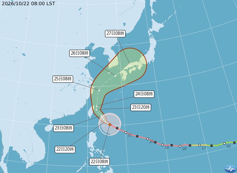
The Taiwan Central Weather Bureau issued a strong typhoon “Qiangpi” maritime and land typhoon warning at 11:30 am today (22nd). It is estimated that the land alert may include the main island, Penghu, Matsu, etc. The northern and Yilan mountain areas should be cautious against heavy rain levels and above.
The Taiwan Central Weather Bureau stated that the center of Typhoon “Qiangpi” at 8 am today was located at 20.3 degrees north latitude, 126.0 degrees east longitude, moving west-northwest at a speed of 13 kilometers per hour. The central pressure is 925 hectopascals, the maximum wind speed near the center is 51 meters per second, and the momentary maximum gust is 63 meters per second. The radius of gale force winds is 300 kilometers on average (330 kilometers on the northwest side, 330 kilometers on the northeast side, 250 kilometers on the southwest side, 300 kilometers on the southeast side), and the radius of storm force winds is 150 kilometers on average (150 kilometers on the northwest side, 150 kilometers on the northeast side, 130 kilometers on the southwest side, 170 kilometers on the southeast side).
The Taiwan Central Weather Bureau stated at 2:30 pm today that according to the latest data, the center of Typhoon “Qiangpi” is currently located southeast of Cape Eluanbi, moving northwest and then north-northwest, posing a threat to Yilan, Hualien, Taitung, Taichung, Nantou, Kaohsiung, and Pingtung areas.
Land alert areas: Yilan, Hualien, Taitung, Taichung, Nantou, Kaohsiung, and Pingtung should be on high alert. Maritime warning areas: Ships operating near Taiwan and the Bashi Channel should be on high alert.
Lin Bing-yu, director of the Meteorological Forecast Division of the Taiwan Central Weather Bureau, said that based on the current path prediction, by this afternoon, the land alert range may cover most of the western part of the island. Due to the wide gale radius of the strong typhoon “Qiangpi”, it is not ruled out that both the main island and Penghu, Matsu, will issue land alerts.
Wu De-rong, associate professor at the Department of Atmospheric Sciences, National Central University, mentioned in the “Weather Machine Classroom” column of the Meteorological Application Promotion Foundation today, that at 2 am today, the Meteorological Bureau’s “Typhoon Path Potential Prediction Map” showed that the strong typhoon “Qiangpi” slightly shifted westward, passing through the sea area between Yilan and Yonaguni Island. The red frame once again touched Taiwanese land, increasing the probability of a landfall, which cannot be completely ruled out.
Wu De-rong pointed out that at 8 pm on the 21st, the European (ECMWF) AI model simulation showed that the ensemble average path continued to turn northwest and then north, passing through the northeastern sea area of Taiwan on the 23rd, and then turning northeast, also approaching the distance from the land; individual members of the ensemble dispersed on both sides, showing uncertainty in the simulated path.
He said that although the strong typhoon “Qiangpi” has peaked and will gradually weaken, its intensity is still strong and its range large. Coupled with approaching the land, it intensifies the threat of strong winds and heavy rains, which should not be taken lightly. It is essential to closely monitor the latest data adjustments and prepare for typhoons.
Wu De-rong stated that at 8 pm on the 21st, the European model simulation showed that the northeasterly winds and the influence of “Qiangpi” peripheral moisture would gradually increase the rain on the windward side and have a minor impact on the leeward side; temperatures would drop, and northern Taiwan would noticeably cool down. By the afternoon of the 24th, typhoon “Qiangpi” would gradually move away, and the wind and rain would gradually weaken.
He mentioned that on the 25th and 26th, the wind and rain would cease, and the weather would improve, with occasional brief showers in the mountainous areas in the afternoon. On the 27th and 28th, the northeasterly winds would strengthen, increasing the probability of brief showers on the windward side, while the leeward side would remain clear and stable.