
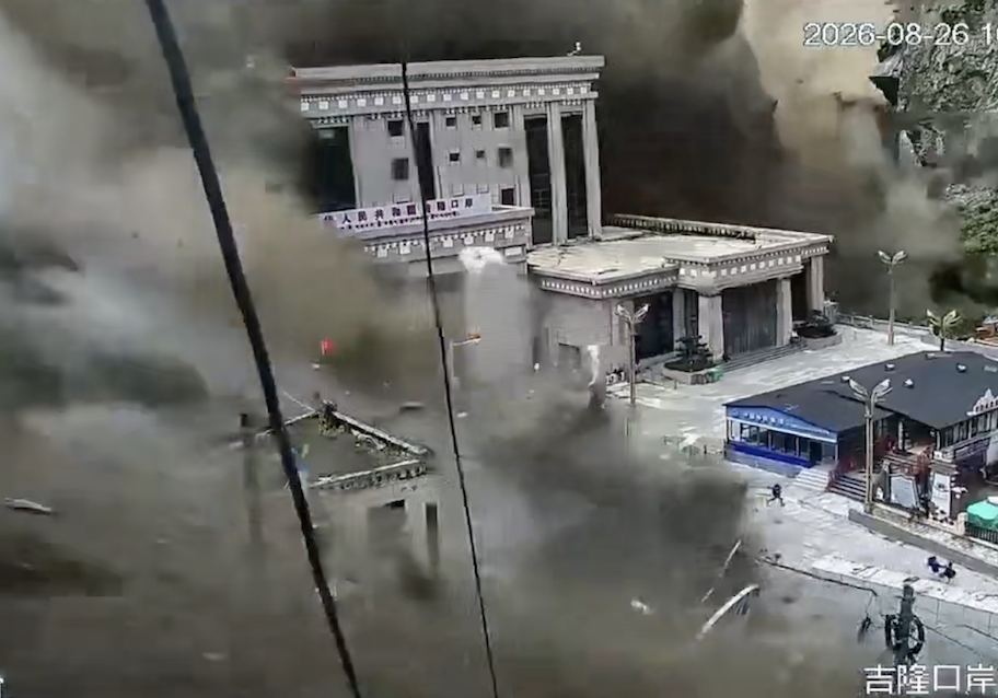
In a tragic mudslide disaster at the Jilong Port on the China-Nepal border, the suddenness of the event, the severity of the impact, the extensive scope, and the high casualty toll have shocked the world.
So far, the Chinese authorities have reportedly received at least three warnings about potential risks in the area: a geological report from 12 years ago, computer simulations, and the destruction of the Friendship Bridge last year. Data indicates that the Chinese officials were aware of the significant geological disaster risks in the Jilong region.
According to related videos, the Jilong Port is located at the confluence of the Jilong Zangbu and Donglin Zangbu rivers, with steep terrain and a narrow valley flanked by high mountains on both sides.
In other words, the customs building, passenger inspection area, and container truck yard at the Jilong Port are all crowded on a limited low-lying area downstream of the rivers, surrounded by high snow-capped mountains.
In this terrain, when floods and mudslides rush down from upstream, the port naturally becomes the most vulnerable area to concentrated impacts. The Jilong Port was built on such a geological landscape.
According to Chinese state media reports, experts from the Chinese Ministry of Natural Resources analyzed that the current disaster was triggered by a glacier collapse in the high mountains of Nepal. Ice blocks, boulders, and sediment rushed downward, picking up loose rocks and soil along the way, forming debris flows that eventually converged into the Donglin Zangbu River, turning into a mudslide impacting the Jilong Port.
Experts estimated that the average speed of the mudslide exceeded 50 meters per second, roughly equivalent to a speed of about 180 kilometers per hour.
In April 16, 2014, the official Tibetan Daily reported that Tibetan officials stated their intention to develop the Jilong Port into a “bridgehead” connecting South Asian trade. They mentioned that the conditions for accelerating the construction of the Jilong Port were in place, with some application materials completed, including the “Jilong Town Geological Hazard Assessment Report” and the “Reso Regional Geological Hazard Assessment Report.”
In other words, before the large-scale development of the Jilong Port, research was conducted by the Chinese side on potential areas of mountain collapses, mudslides, and dangerous building locations.
The official Chinese report mentioned that these assessments were completed at the time to “accelerate port construction.”
The crucial question that arises is not merely whether these studies were carried out but rather whether they were used for disaster prevention purposes or simply to expedite port construction.
A study published in the Journal of Chinese Geology Hazards and Prevention in 2015 stated that following the earthquake in Nepal in 2015, Chinese geologists surveyed 183 geological disaster sites in the Jilong County, including landslides, avalanches, and mudslides. Over 80% of these were concentrated in three areas in Jilong Town, Gongga Town, and Gongdang Township.
This indicates that such geological disasters were not a sudden occurrence but had been previously investigated, documented, and studied within Chinese borders.
By February 2025, a research led by scientists from the Chinese Academy of Sciences and the University of Chinese Academy of Sciences published a study in the International Journal of Disaster Risk Reduction. They utilized computer simulations to analyze the potential routes, distances, areas covered, and threats posed to buildings and infrastructure if a high mountain glacier lake burst near the China-Nepal border.
The term “glacial lake outburst flood” refers to a natural reservoir surrounded by ice and rocks suddenly bursting, leading to a massive flow downhill.
According to the study, the flood from a glacial lake outburst could threaten over 3,000 buildings, around 50 bridges, 9 hydroelectric power stations, and 50 kilometers of roads.
The primary funding source for this research was a scientific research program under Chinese official backgrounds, with the report explicitly stating that it aimed to support both governments in formulating comprehensive disaster risk reduction strategies.
In light of this, the computer model was not predicting a specific disaster date but rather outlining the potential impact zones if a high mountain glacial lake flood occurred and which areas would be most at risk.
After the study’s publication, approximately five months later, the risks revealed by the research were validated in real life.
In July 2025, a glacial lake outburst flood occurred upstream of the Jilong Port, causing a flash flood and mudslide that destroyed the Reso Bridge (Friendship Bridge), resulting in the closure of the port and casualties on both the Chinese and Nepalese sides.
Reports at the time highlighted that studies from Chengdu University of Technology revealed the existence of 55 glacial lakes in the upstream watershed of the Friendship Bridge, with a total area of approximately 3.39 square kilometers.
Additional reports suggested the necessity of enhancing upstream flood warnings to prevent another glacial lake outburst flood, urging detailed assessments of the feasibility and risks of all glacial lakes in the region.
In conclusion, it becomes apparent that the issue was not merely about ignorance of risks beforehand but rather the entire watershed had experienced floods before, research had warned about the risks, and the potential of another glacial lake burst flood still loomed.
Yet, questions arise as to why the Chinese authorities, despite knowing about the high-risk zone, hurried to resume operations at the port, facilitating the passage of travelers and cargo trucks and bringing in personnel and goods from Nepal. What interests and pressures lie behind the Jilong Port?
A report by Xinhua News Agency emphasized that in 2024, the import and export trade volume processed at the Jilong Port reached 4.248 billion RMB, nearly one-third of the total Sino-Nepal trade volume.
Jilong is not just an ordinary small port in the mountains but rather a crucial strategic gateway for China to access South Asian trade, tourism, and political influence. The higher the economic and geopolitical value, the greater the pressure to reopen the port.
This raises the question: following the flood in 2025, were the passenger building and truck parking area relocated from the low-lying flood-prone zones? Were limits placed on the number of people and vehicles allowed at the port simultaneously? Were alarm systems installed? Were clear evacuation routes planned?
However, while Xinhua News Agency detailed the resumption of truck traffic on the bridge, it did not address these safety arrangements.
When interviewed after the recent August incident at the Jilong Port, Xu Qiang, Vice President of Chengdu University of Technology and Executive Deputy Director of the National Key Laboratory of Geological Disaster Prevention and Geological Environmental Protection, made a crucial statement.
He believed that the extensive devastation in this disaster was due to the high exposure of the affected area. Numerous buildings, roads, and bridges in the Jilong Port and Nepal region are built directly in the path of mudslides, exposed due to their lower positioning, lacking buffer zones, resulting in severe destruction.
Xu Qiang proposed practical suggestions from an engineering perspective: to fundamentally avoid risks, it’s essential to relocate infrastructures by raising their elevation, which means increasing their altitude above the flood lines of mudslides and flash floods.
According to Xu Qiang’s remarks, it appears that the Chinese authorities may have a direction for solving the issues. Why were these steps not taken in the past? Why did these suggestions only surface following the second major disaster, nearly destroying the entire port?
What exactly were written in the two geological hazard assessment reports completed by officials in 2014? Did they contain similar warnings? Were there assessments warning about the risks of glacial lake outburst floods, flash floods, and mudslides at the Jilong Port?
After the computer simulation results were made public and after the destruction of the Friendship Bridge in 2025, did the Chinese authorities conduct a new safety evaluation? What did the safety evaluation written before the port resumed its operations entail?
Before the reopening in January 2026, were complete safety approvals obtained? Was the reopening contingent on ensuring safety, or was it rushed to expedite trade?
These are crucial and unavoidable questions that people are deeply concerned about, and the Chinese authorities cannot overlook them.