
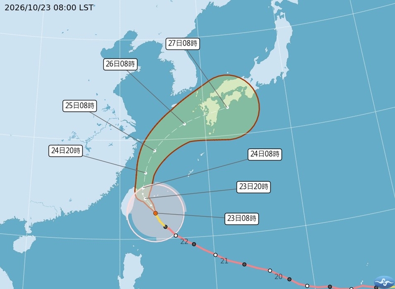
Taiwan’s Central Weather Bureau indicated today (23rd) that as Typhoon “Qiangpi” gradually approaches Taiwan, the eyewall has engulfed the island. The Central Disaster Response Center reported a total of 1 death and 94 injuries across Taiwan during the impact of Typhoon “Qiangpi”. Meteorological experts emphasized that the intensity of the typhoon remains strong and its scope is large, urging the public not to underestimate its impact.
The Central Weather Bureau stated that as of 8 a.m. today, Typhoon “Qiangpi” was located at 22.6 degrees north latitude, 123.9 degrees east longitude, moving at a speed of 19 kilometers per hour in a north-northwest direction. The central pressure was 945 hPa, with maximum sustained winds near the center reaching 43 meters per second and maximum instantaneous gusts of 53 meters per second. The average radius of gale-force winds extends 320 kilometers (330 kilometers on the northwest side, 350 kilometers on the northeast side, 270 kilometers on the southwest side, and 310 kilometers on the southeast side), with the average radius of storm-force winds reaching 120 kilometers.
The Central Disaster Response Center reported that during the passage of Typhoon “Qiangpi”, there have been a total of 1 fatality and 94 injuries across Taiwan, with an increase of 52 injuries compared to the previous night, of which motorcycle falls and traffic accidents accounted for the highest number of injuries at 30.
The Central Weather Bureau issued a special warning for strong winds on land due to the influence of Typhoon “Qiangpi” and its outer circulation. From this morning until the 24th at night, there is a probability of wind speeds averaging above 12 levels or gusts above 14 levels in certain areas of Penghu County (Xiyu). Other areas like Keelung City, New Taipei City, Taoyuan City, Hsinchu City, Hsinchu County, Miaoli County, Taichung City, Changhua County, Yunlin County, Chiayi County, Tainan City, Kaohsiung City, Pingtung County, Yilan County, Hualien County, Taitung County (including Lanyu and Green Island), and parts of Lienchiang County have a chance of wind speeds averaging above 9 levels or gusts above 11 levels. Areas like Taipei City, Nantou County, and parts of Chiayi City may experience winds averaging above 6 levels or gusts above 8 levels. Citizens are advised to take precautions.
The Central Weather Bureau also issued a heavy rain warning due to the influence of Typhoon “Qiangpi” and its outer circulation. Today, there may be localized heavy or extremely heavy rainfall in mountainous areas of Yilan County, and localized heavy or heavy rainfall in Taipei City, New Taipei City, Taoyuan City, Hsinchu County, and Miaoli County. Additionally, regions such as Keelung City, Taipei City, New Taipei City, Taoyuan City, Hsinchu County, Yilan County, Taichung City, Nantou County, and Hualien County could experience localized heavy rain or heavy rainfall in mountainous areas.
Furthermore, there is a probability of localized heavy rain in the areas of Hsinchu, Miaoli, Taichung, and Hualien, as well as Yunlin, Chiayi, and the mountainous regions of Kaohsiung, so residents are advised to be cautious of sudden heavy rain, potential landslides, rockfalls, debris flows in mountainous areas, and flooding in low-lying areas. Areas expecting extremely heavy rainfall: Yilan County; Heavy rainfall areas: Taipei City, New Taipei City, Taoyuan City, Hsinchu County, and Miaoli County.
Taiwan’s National Central University’s Department of Atmospheric Sciences adjunct associate professor, Wu Derong, expressed in the “Sky Machine Classroom” column of the Meteorological Applications Promotion Fund that Typhoon “Qiangpi” has challenged technological limits by not following the AI model’s early turn to the north or the traditional dynamical model’s direct westward landfall route, instead opting for an intermediate path.
Wu stated that according to the Central Weather Bureau’s typhoon path potential prediction chart, Typhoon “Qiangpi” is currently situated in the eastern seas of Taiwan, moving northwestward, expected to pass near the northeast coast tomorrow morning before turning north and then northeast, gradually weakening. The probability of a direct landfall remains low, but cannot be ruled out entirely.
Moreover, Wu pointed out that although “Qiangpi” has peaked and is gradually weakening, its intensity remains strong, coupled with its large scope and proximity to land, posing threats of strong winds and heavy rainfall that should not be taken lightly. Continuous monitoring of the latest data adjustments is recommended, along with taking necessary precautions against the typhoon.
Wu further mentioned that the latest simulation from the European Center for Medium-Range Weather Forecasts (ECMWF) AI model indicates that for the next two days, the northern regions, Yilan, Hualien, and mountainous areas should be cautious of strong winds and heavy rainfall leading to disaster. Although impacts on flat areas facing away from the wind are relatively minimal, precautions against strong gusts and sudden heavy rain are still advised. By the latter half of the 24th, “Qiangpi” is expected to move further away, reducing wind and rain.
Looking ahead, Wu stated that weather conditions are projected to improve on the 25th and 26th, with temperatures rising and occasional localized brief rainfall in the mountains during the afternoon. By the 27th and 28th, the northeast monsoon will strengthen, bringing the chance of localized brief rainfall on windward slopes, with stable and clear conditions on leeward sides.
By the 29th, the northeast monsoon is expected to weaken, leading to improved weather conditions and a rise in temperatures. However, Wu cautioned that the typhoon season is not yet over, with the forecast indicating the possible formation of typhoons in the distant seas east of Guam next week, which is unlikely to affect Taiwan.