
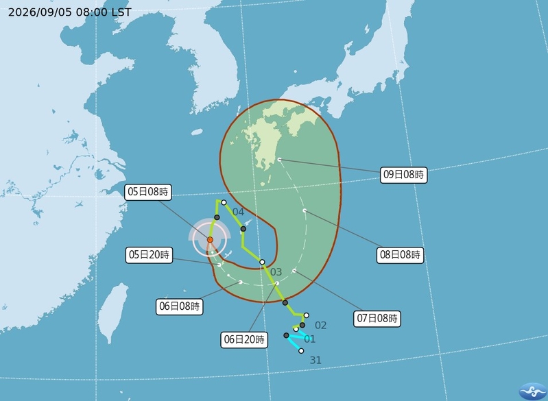
Taiwanese meteorologist Wu Derong said that Tropical Storm KoroWang continues to shift and meander near the Ryukyu Islands in Japan, with a high degree of uncertainty. Former director of the Central Weather Bureau, Zheng Mingdian, mentioned that KoroWang has strengthened and is currently being influenced by both the tropical storm and the northeasterly monsoon, affecting Japan.
Associate Professor Wu Derong from the Department of Atmospheric Sciences at National Central University stated on September 4th, during the “Heaven’s Machine Classroom” column of the Meteorological Applications Promotion Foundation, that according to the latest European (ECMWF) model simulations, there may be occasional brief localized rainfall in various regions from September 4th to September 6th. The northern regions and mountainous areas in the afternoon may experience more significant rainfall, with the possibility of localized convection development, requiring attention to associated lightning, strong winds, and sudden heavy rainfall.
Wu Derong mentioned that the latest model simulations indicate that from the daytime of September 7th to the 9th, a large cyclonic circulation will gradually shift towards the eastern waters of Taiwan. Northeast winds will prevail, with less moisture and a more stable atmosphere. Cloud cover will be higher in the northern windward areas, with occasional brief localized rainfall. The leeward areas will be mostly clear to partly cloudy, marking the end of the consecutive rainy weather pattern.
He further explained that from September 10th to the 11th, moisture from the northeast winds will gradually increase, leading to more localized brief rainfall in the northern and eastern parts, while the leeward areas will continue to be clear and stable.
Regarding Tropical Storm KoroWang, Wu Derong stated that within the large cyclonic circulation, it is moving south near the Ryukyu Islands in Japan, under its guidance, moving counterclockwise, with a high level of uncertainty.
Former Central Weather Bureau director Zheng Mingdian remarked, “Tropical Storm KoroWang has grown up! One notable feature is the long cloud band extending northeast of the storm, which signifies the convergence of the tropical storm and the northeasterly monsoon, currently impacting certain regions of Japan. However, due to the terrain, this convergence effect will not lead to a significant increase in rainfall in Japan.”