
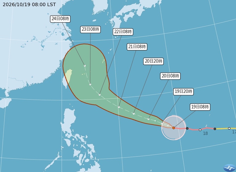
On October 19, 2026, Taiwan’s meteorological expert Wu Derong pointed out that according to the European model simulation, the strong typhoon Qiangpi may land or pass near the northern coast of Taiwan, and the threat of strong winds and heavy rain should not be underestimated.
The Central Weather Bureau of Taiwan stated that as of 8:00 on the 19th, the center of Typhoon Qiangpi was located at 14.0 degrees north latitude and 139.2 degrees east longitude, moving west-northwest at a speed of 19 kilometers per hour. The central pressure was 915 hectopascals, with a maximum wind speed near the center of 53 meters per second, and maximum gusts of 65 meters per second. The radius of strong winds averaging Force 7 was 220 kilometers (220 kilometers on the northwest side, 240 kilometers on the northeast side, 200 kilometers on the southwest side, and 230 kilometers on the southeast side), while the radius of strong winds averaging Force 10 was 100 kilometers (100 kilometers on each side).
Associate Professor Wu Derong from the Department of Atmospheric Sciences at National Central University in Taiwan mentioned in a column in the Meteorological Application Promotion Foundation’s “School of Weather” that the latest “Typhoon Path Potential Forecast Map” from the Central Weather Bureau indicates that Typhoon Qiangpi, the 29th typhoon of the year, is currently at sea west of Guam and is moving towards the eastern waters of Taiwan in a west-northwesterly direction. The uncertainties in the path include possible “landfall” or a northward turn near Taiwan. Typhoon Qiangpi is expected to strengthen and expand further, reaching its peak today and on the 20th.
According to Wu Derong, based on the latest European model simulation, Typhoon Qiangpi is most likely to continue moving west-northwest towards Taiwan, with the center possibly making landfall or passing near Taiwan. Although Qiangpi is expected to weaken gradually as it approaches Taiwan, its intensity remains strong, and the threat of strong winds and heavy rain should not be underestimated. The models will continue to adjust, so close monitoring is necessary.
Wu Derong also mentioned that the latest European model simulation indicates that for the next two days, the weather will be sunny and stable in the western half of Taiwan, while the eastern half will be partly cloudy with occasional brief showers. Daytime temperatures will be relatively high throughout the region, with significant temperature differences between day and night, resembling a “late summer heatwave” pattern.
Furthermore, Wu Derong highlighted that according to the latest model simulation, on the afternoon of the 21st, the northeast monsoon will strengthen, bringing rain on windward-facing areas. On the 22nd, the rainfall on windward-facing areas will gradually increase, with minor impacts on leeward areas, and temperatures will gradually decrease each day.
As per Wu Derong, the latest model simulation indicates that on the 23rd and 24th, the severity of wind and rain in various regions will depend on whether Typhoon Qiangpi makes landfall, leading to uncertainties that require further observation. By the 25th, Typhoon Qiangpi will be moving away, leading to a cessation of wind and rain, and a return to stable weather conditions.