
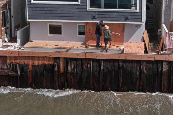
On September 27th, Hurricane Polo began causing high tides on some beaches in Southern California, with meteorologists warning of potential coastal flooding, severe beach erosion, and dangerous rip currents in the days to come.
According to a report from the city news agency, the National Weather Service in the United States stated that Hurricane Odalys is currently active in the waters off central Mexico, and the southward surges from both hurricanes are expected to continue affecting Southern California until Tuesday, September 29th.
From Sunday to Tuesday, waves on south-facing beaches may occasionally reach 4 to 7 feet (1.2 to 2.1 meters), but forecasters said that due to uncertainties in the hurricanes and their paths, wave heights could fluctuate by around 2 feet (0.6 meters).
The National Weather Service mentioned that the tides will continue to amplify, reaching a peak of around 7 feet on Monday and Tuesday. Due to the ongoing impact of the El Niño phenomenon, this tide is expected to be nearly 1 foot higher than the astronomical tide (the normal predictable tide level purely caused by celestial gravity and Earth’s motion).
Forecasters stated, “Therefore, there is significant concern that vulnerable south-facing beaches may experience coastal flooding, but the severity of the flooding is still uncertain.”
The most worrisome areas include Avalon, Long Beach, and Malibu.
Forecasters advised that beach areas facing south should be prepared, as low-lying walkways, parking lots, and roads could be submerged in shallow seawater, with the potential for serious beach erosion. In the most vulnerable areas, some buildings may also suffer partial damage.
The meteorological department mentioned that the “reasonable worst-case scenario” could result in effects similar to Hurricane Marie earlier this month, which caused significant damage to residences in Dana Point, Long Beach, and Malibu.
The National Weather Service pointed out that Avalon might be particularly vulnerable to the impacts, as the surges brought by Hurricane Polo are expected to be more southeastward than those of Hurricane Marie, making the area more susceptible to impact.
Forecasters noted that the current situation remains quite complex, as Hurricane Polo and Hurricane Odalys are closer to each other, making it challenging for computer models to accurately predict the path of Odalys. Additionally, Hurricane Polo is expected to be in a sufficiently westward position for only a brief period, allowing its waves to smoothly advance toward Southern California.
Los Angeles’ Emergency Management Department issued a warning on September 25th, reminding residents to prepare for the hurricane’s impact, including the increased risk of drowning. Authorities stated that widespread and very strong rip currents could potentially sweep swimmers and surfers out to sea.
Authorities suggested that residents in areas prone to coastal flooding could visit various fire stations of the Los Angeles Fire Department to obtain sandbags for self-filling and to access information on properly placing them.
In Long Beach, the Fire Department’s Maritime Safety Division and the city’s Public Health Department are assisting in coastal disaster preparedness to address the expected high tides and surges. The Public Health Department’s logistics team arrived on the morning of the 26th, transporting filled sandbags and additional empty ones. The Claremont Parking Lot also has sand and sandbags available, located at 5400 E. Ocean Blvd.
Los Angeles County beaches have issued a beach hazard statement effective until early Monday, along with coastal flooding alerts for Monday and Tuesday.
Orange County has issued a beach hazard statement in effect until late Sunday night, as slight seawater overflow is anticipated on Sunday; coastal flood warnings have been issued until 5 p.m. on Wednesday.
After the hurricane’s impact, temperatures are expected to rise. Starting from Wednesday, the highest temperatures in many inland valleys are forecasted to reach 90 to 100 ℉ (around 32 to 37.8 °C), continuing through the weekend.