
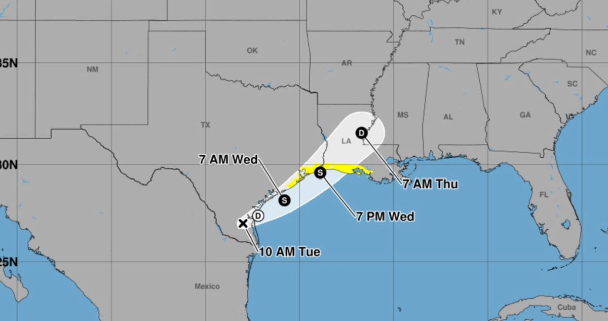
Tropical Storm Bertha made landfall on Thursday afternoon (July 23) at the border area between Texas and Louisiana in the United States. Several parts of Texas are facing the risks of heavy rainfall and flash floods.
Prior to this, Bertha had already struck the southern part of Louisiana on Wednesday (July 22).
The National Hurricane Center in the United States reported on Thursday afternoon that Bertha had a maximum sustained wind speed of 45 miles per hour (approximately 72 kilometers per hour) at the time of landfall.
The center stated on the X social media platform that Bertha had moved inland near the border area of Texas and Louisiana, with coastal areas of Texas facing heavy rainfall.
Meteorologist Breanna Grill from the commercial meteorological forecasting company AccuWeather mentioned in a report that southern and coastal parts of Texas are expected to receive an additional 2 to 4 inches (approximately 5 to 10 centimeters) of rainfall, with the main threats being flash flooding and storms.
She also pointed out that due to a deadly flood that occurred in hilly regions of Texas just last week, the current storm could easily lead to another flood disaster.
The National Hurricane Center also warned that the heavy rainfall from this storm could cause localized flooding in urban areas, and water levels in coastal areas of Louisiana and Texas could rise by up to 2 feet (about 0.61 meters) due to storm surge.
Tropical storm warnings have been issued from Morgan City in Louisiana to Sargent in Texas along the Gulf of Mexico coastline. The National Weather Service has also issued flood alerts and coastal flood advisories simultaneously.
With sustained winds of 45 miles per hour, Bertha is capable of toppling trees or power lines. However, as of Thursday evening, there were no reports of widespread power outages in Texas.
Meteorologists stated that the heaviest bands of rainfall are still mostly offshore, but some heavy rain could move inland, potentially advancing further into the hilly regions of Texas, which are still recovering from a deadly flood earlier this month.
According to the National Hurricane Center’s forecast, the intensity of Storm Bertha will gradually weaken as it moves further inland. While it is predicted to maintain tropical storm status on Thursday night, by Friday morning (July 24), it is expected to weaken to a tropical depression.
AccuWeather forecasts that the storm will continue to sweep across Texas after landfall and is expected to completely dissipate by Friday night.
Climate scientist Jay Grymes from Louisiana stated during an interview on Wednesday that he expected localized flooding in parts of Texas, but if conditions progress as expected, this will be a fast-moving storm.
Earlier this week, Bertha had caused storm surges along the coasts of Florida and Alabama.
Bertha is the second named storm of the 2026 Atlantic hurricane season. The first storm, Arthur, made landfall along the Gulf Coast of Texas in June, with some coastal areas of Mississippi still recovering from the flood damage caused by Tropical Storm Arthur.