
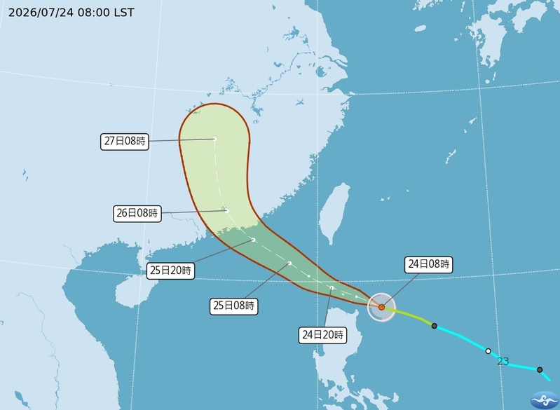
Taiwan’s Central Weather Bureau stated that Typhoon Hongxia has strengthened in intensity, with the wind radius increasing. The typhoon is expected to come closest to Taiwan from this evening (24th) to tomorrow morning (25th). Meteorological experts mentioned that today, the western half of Taiwan will be affected by the outer bands of Typhoon Hongxia and descending airflow due to mountain terrain, while the eastern half will experience increasing humidity, leading to more pronounced rainfall from the Hengchun Peninsula in the south to the northeast corner in the north.
According to the Taiwan Central Weather Bureau, as of 8 a.m. today, the center of Typhoon Hongxia was located at 18.6 degrees north latitude and 123.6 degrees east longitude, moving at a speed of 26 kilometers per hour in a west-northwesterly direction. The central atmospheric pressure was 995 hPa, with maximum sustained winds near the center reaching 20 meters per second and maximum gusts of 28 meters per second. The radius of strong winds extending from the center reached 80 kilometers (70 kilometers on the northwest side, 80 kilometers on the northeast side, 60 kilometers on the southwest side, and 90 kilometers on the southeast side).
The Taiwan Central Weather Bureau highlighted that the intensity of Typhoon Hongxia and its wind radius will continue to strengthen and expand. Tonight until tomorrow morning will see it closest to Taiwan, requiring precautions in the Hualien-Taitung area and the Hengchun Peninsula against heavy rainfall. The typhoon is expected to possibly intensify to a medium typhoon, but by then, Taiwan is forecasted to be out of the marine warning zone.
Wu Derong, an associate professor at the Department of Atmospheric Sciences at National Central University in Taiwan, mentioned in the “Sky Machine Classroom” column of the Meteorological Applications Promotion Foundation that the latest European (ECMWF) model simulation indicates that the western half of Taiwan will experience sunny and stable weather with high temperatures due to the outer bands of the typhoon and descending airflow. Sun protection and prevention of heat stroke are advised. Meanwhile, the eastern half of the island will see increasing humidity, with rainfall becoming more prominent from the Hengchun Peninsula in the south to the northeast corner.
Wu further elaborated that tomorrow, the outer cloud bands of Typhoon Hongxia will expand the rain coverage, with the southern areas including Hualien and Pingtung needing to beware of rain disasters. The central regions may experience sporadic brief showers, while the influence on the northern areas will be minimal. Over the next two days, the northern regions should guard against “extreme high temperatures” during the day, with expected temperatures ranging from 23 to 37 degrees Celsius in the north, 23 to 37 degrees in the central regions, 25 to 37 degrees in the south, and 23 to 35 degrees in the east.
Regarding future weather conditions, Wu pointed out that the latest model simulations indicate that on the 26th, there will be localized showers in the eastern, southeastern, and southern regions, spreading to other areas in the afternoon. He highlighted that on the 27th and 28th, with the influence of southerly winds and residual moisture from Typhoon Hongxia, localized rainfall is expected in the southeast and south, prompting the need for vigilance against localized strong convective activity in the unstable atmosphere until the rain arrives, the weather will be hot.
Looking ahead to July 29th to August 1st, the moisture in the atmosphere will decrease, the Pacific high pressure system will slightly strengthen, leading to increasingly stable atmospheric conditions. Expect clear and hot weather throughout Taiwan, with the possibility of localized thunderstorms in the mountains in the afternoon.