
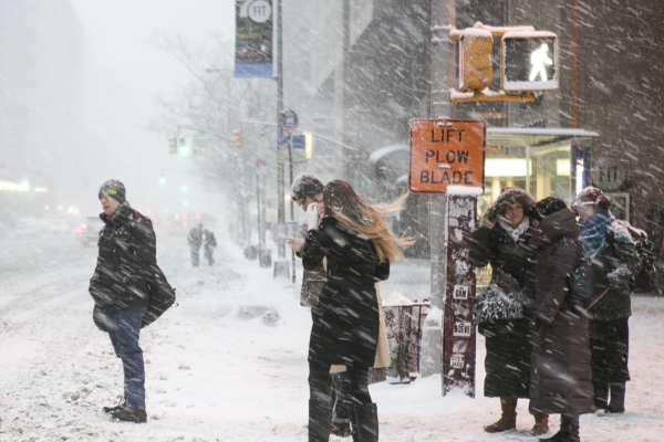
The northeastern United States welcomed its first significant winter storm on Tuesday (December 2), with snowfall reaching up to 1 foot (approximately 30 cm). At almost the same time, the Midwest region began to dig out from the ice and snow that caused traffic chaos following the Thanksgiving holiday.
According to the report from the Associated Press, meteorologists stated that a windy storm bringing potential ice was heading towards the region, potentially affecting parts of six states in the Northeast with wet snow, while other areas could see significant snow accumulation. Northern parts of New England are expected to see snowfall amounts as high as 10 inches (about 25 cm).
Ahead of the snowfall, the National Weather Service issued winter storm warnings and winter weather advisories for states including Massachusetts, New Hampshire, Vermont, Maine, Connecticut, and New York. As of Tuesday morning, the snowfall persisted throughout the region.
Meteorological data shows that several days before this winter weather hit, Chicago O’Hare International Airport recorded over 8 inches (about 20 cm) of snowfall over the weekend, setting a record for the highest single-day snowfall in November in the airport’s history, surpassing the previous record set in 1951.
Meteorologist Andrew Orrison from the National Weather Service stated that while snowfall in the Great Lakes region is diminishing, a new storm is heading towards the Mid-Atlantic and Northeast, with snowfall expected to reach up to 1 foot (about 30 cm) by Tuesday. Hundreds of flights were delayed due to the snowfall.
Orrison said, “This will be the first significant snowfall of the season for many areas, and the snow amounts will be substantial.”
Meteorologically speaking, winter (December to February) is the season adopted by climate scientists for continuous records, which differs from most astronomical seasons on the calendar.
The National Weather Service issued a snowfall warning for coastal areas of Maine, with the warning in effect from Tuesday morning through Wednesday morning, advising residents to “delay all travel if possible” due to the snowfall. Forecasters stated that Maine is one of the many states bracing for the first wave of snowfall in December.
Due to officials warning of potentially hazardous road conditions, schools and government offices in various parts of the Northeast have been closed. Dozens of schools in northern New York canceled classes, with parts of the eastern region of the state expecting over 6 inches (around 15 cm) of snowfall. Snow began before dawn, leading to slippery roads during the morning commute.
In New Hampshire, the transportation department invited residents on Sunday to submit names for its second annual “Name the Snowplow” contest.
On Tuesday, Ohio remained under a winter weather advisory, with icy road conditions causing travel disruptions and school closures. According to the National Weather Service, nighttime snowfall accumulated 3 to 5 inches (about 7 to 12 cm) in parts of the southern region of the state.
Numerous traffic accidents were reported. In northern parts of the state, a section of westbound I-70 in the Cleveland area had to be closed for cleanup following an accident, while highways around Columbus experienced dangerous slow-moving traffic.
Forecasters urged people to remain vigilant as slippery road surfaces and low visibility conditions are expected to persist.
Marissa Orbanek, the news secretary for the Pennsylvania Turnpike Commission, stated that as snow accumulation reached shovelable levels in parts of Pennsylvania, crews have begun clearing the state’s 565-mile (909 km) toll road system.
At 5 a.m. on Tuesday, vehicle restrictions were implemented on several interstate highways in eastern Pennsylvania, including the Northeast Extension from the Lehigh Valley to Clarks Summit.
By Tuesday morning, snowfall had stabilized in the Lehigh Valley area. Traffic speeds slowed to a crawl near Kutztown on I-78 due to the snowfall.
Orbanek mentioned that over 600 equipment operators and safety personnel are on standby to help clear the toll road system’s 2,900-mile (4,667 km) lanes. Winter personnel deployments for the toll road system began in mid-November, with 23 maintenance sheds staffed with round-the-clock personnel.
“We are always prepared for snow year-round,” Orbanek said.
Ashton Robinson Cook from the National Weather Service’s Weather Prediction Center stated that the current winter storm sweeping through the Mid-Atlantic and Northeast initially started as a weaker system in the Midwest but strengthened as it approached coastal waters.
He noted that while such storms are not common, they are not entirely beyond the realm of possibility. The next system may also bring winter weather to the Mid-Atlantic region from Friday into Saturday.