
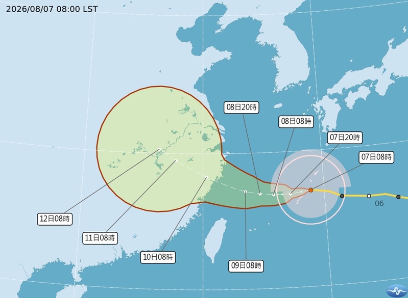
Taiwan meteorological experts said today (7th) that Typhoon Baihaidu would move westward, gradually weaken, and pass near the Ryukyu Islands today. There is a high probability of heavy rainfall in northern, central, and southern Taiwan from the 8th to the morning of the 10th.
The Central Weather Bureau of Taiwan stated that as of 8 a.m. today (7th), the center of Typhoon Baihaidu was located at 27.1 degrees north latitude, 128.9 degrees east longitude, moving westward at a speed of 13 kilometers per hour. The central pressure is 955 hPa, with a maximum wind speed of 38 meters per second near the center and a maximum gust of 48 meters per second. The radius of gale-force winds is 280 kilometers on average (330 kilometers on the northwest side, 330 kilometers on the northeast side, 230 kilometers on the southwest side, and 230 kilometers on the southeast side), and the radius of violent gale-force winds is 90 kilometers on average (100 kilometers on the northwest side, 100 kilometers on the northeast side, 70 kilometers on the southwest side, and 70 kilometers on the southeast side).
The Central Weather Bureau of Taiwan stated that if the predicted direction and speed of Typhoon Baihaidu remain the same, a maritime typhoon warning will be issued at 2:30 p.m. today, with the likelihood of a land warning being highest for Matsu from the evening of the 8th to the morning of the 9th.
Associate Professor Wu Derong of the Department of Atmospheric Sciences at National Central University of Taiwan stated in the “Sky Machine Classroom” column of the Meteorological Application Promotion Foundation today that Typhoon Baihaidu is moving westward, gradually weakening, passing near the Ryukyu Islands today, entering the southern East China Sea on the 8th, slowing down in speed, with increasing uncertainty, and is expected to make landfall in Zhejiang on the morning of the 10th.
The Japan Meteorological Agency issued a potential typhoon path prediction map at 10:45 a.m. today, with Typhoon Baihaidu located near Okinotorishima Island at 10 a.m., with a central pressure of 950 hPa, a maximum wind speed near the center of 40 meters per second, and a maximum gust of 55 meters per second. The Okinawa Prefecture Government stated that as of 7 a.m. today, 244 people were evacuated at 34 local administrative units on Okinawa Island and the Daito Islands, and 3 people were known to be injured in Okinawa Prefecture.
Wu Derong stated that the latest European Centre for Medium-Range Weather Forecasts (ECMWF) model simulation shows that after Typhoon Baihaidu enters the southern East China Sea on the 8th, the probability of completely bypassing the path by turning north decreases, while the probability of gradually turning westward towards China increases. There is a risk that its wind field may not have enough time to avoid the maritime warning area, so close monitoring is advised.
In addition, Wu Derong mentioned that Typhoon Changhong is expected to move northwestward towards northern Japan.
Wu Derong said that from today to the 9th, the circulation of Typhoon Baihaidu will pass over the northern sea areas, with the center expected to make landfall in Zhejiang on the morning of the 10th. While the northern and central southern parts of Taiwan will experience brief local showers today due to its peripheral influence, the weather will remain hot. From the 8th to the morning of the 10th, there is a probability of severe rainfall in northern Taiwan and central southern Taiwan. It will be slightly cooler, but extreme high temperatures should be guarded against in the eastern regions due to downsloping winds from the mountains. Strong gusts are expected in various locations; special attention should be paid.
Premier Su Tseng-chang of the Republic of China instructed the Office of Disaster Prevention and Rescue Affairs of the Executive Yuan on the 6th to convene a preemptive intelligence assessment meeting to strengthen preventive preparation in high-risk disaster areas.
Wu Derong pointed out that from the 10th to the 12th, as Typhoon Baihaidu moves away and Taiwan experiences southwest winds, there will be local showers or thunderstorms in the southwest-facing regions with potentially heavy rains. The rest of the areas will be sunny and hot, with extreme high temperatures to be wary of in the northern and southeastern regions. There is also a probability of local thunderstorms in the afternoon in the north and central regions.
Wu Derong mentioned that on the 13th and 14th, the southwest winds will weaken, but there will still be abundant moisture. In the early morning, there will be local rainfall in the southwest, and due to atmospheric instability, there may be intense convective activities in the western half in the afternoon.