
This week, the United States and the Philippines conducted a joint patrol near the Scarborough Shoal (known as Huangyan Island in China). Satellite images suggest that the Chinese Communist Party (CCP) may be preparing to build new military and infrastructure facilities in this hotspot in the South China Sea. The joint military operation by the US Coast Guard and the Philippine Armed Forces reflects the Philippines’ concerns about Beijing’s actions and the joint response by the US and the Philippines.
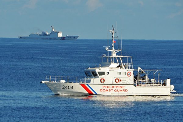
According to a report from the U.S. Naval Institute (USNI) website, the joint exercise between the US and the Philippines took place from May 26th to 30th. It marked the first time that a US Coast Guard ship participated in maritime activities with the Philippine Armed Forces. These maritime exercises, known as “joint patrols,” aim to demonstrate the firm resolve of the US-Philippine alliance in maintaining their positions in disputed waters. The significance of such exercises was confirmed by the US and the Philippines in 2023 following a series of provocative actions by the CCP near the disputed reefs in the preceding year that escalated tensions.
During this joint maritime operation, the US Coast Guard Cutter “Midgett” (USCGC Midgett, WMSL-757) collaborated with the Philippine Navy’s “BRP Antonio Luna” frigate (FFG-14) and the Philippine Coast Guard patrol vessel “BRP Melchora Aquino” (MRRV-9702). The focus of the exercise was on maritime law enforcement training, including procedures for intercepting suspicious vessels and conducting boarding inspections.
Ship tracking data released by the SeaLight Foundation shows that the activities of US and Philippine vessels were located approximately 35 to 40 nautical miles from the reefs in the South China Sea that are “occupied and controlled” by the CCP.
“The direct involvement of the US Coast Guard in the Philippines’ response and challenge to China’s maritime aggression in the ‘West Philippine Sea’ (South China Sea) signifies a milestone in the US-Philippine alliance,” the SeaLight Foundation stated in a social media post.
The Scarborough Shoal, known as “Bajo de Masinloc” in the Philippines and “Huangyan Island” in China, is a significant reef island in the South China Sea. A conflict incident in 2012 sparked a series of tensions between China and the Philippines. The reef is approximately 120 nautical miles from the Philippine island of Luzon and about 350 to 400 nautical miles from China’s Hainan Island. Since the initial standoff, the CCP has maintained occupation and control of Scarborough Shoal through the continuous deployment of quasi-military vessels, coast guard ships, and warships.
Following the joint maritime patrol by the US and the Philippines, the Southern Theater Command and Maritime Safety Administration of the CCP claimed to conduct exercises around Huangyan Island to counter “intrusions and provocations.” The Philippine military disregarded such exercises.
Last fall, the CCP established a “national-level natural reserve” on Huangyan Island, raising concerns reminiscent of past instances where civilian developments in disputed areas escalated into full military mobilizations. The Philippines raised alarm over this move. In the subsequent months, the US maintained a carrier strike group in the region, a regular deployment in the South China Sea.
During the 2026 Asia Security Conference – Shangri-La Dialogue, Philippine Defense Minister Gibo Teodoro revealed to reporters that he was verifying preliminary reports of potential military and infrastructure construction by China in Scarborough Shoal. Teodoro noted that the data was still in the “preliminary” stage but that the Philippine Armed Forces were actively monitoring the shoal.