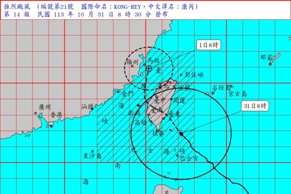
Taiwan’s Central Weather Bureau reported this morning at 8:30 a.m. that Typhoon Kong-rey, over the past 3 hours, had slightly weakened in intensity. Its typhoon eye had entered the land areas of Yilan, Hualien, Taitung, and south of Hsinchu, posing a threat to various regions of Taiwan, Penghu, Kinmen, and Matsu.
The Central Weather Bureau issued maritime and land typhoon warnings today for Super Typhoon Kong-rey (internationally named KONG-REY). At 8 a.m., its center was located at 21.8 degrees north latitude, 122.2 degrees east longitude, about 130 kilometers east of Cape Eluanbi, moving northwest to north at speeds of 28 to 19 kilometers per hour.
According to the latest data, the Central Weather Bureau stated that Typhoon Kong-rey had slightly weakened in intensity over the past 3 hours. Its center is currently located in the sea area east of Cape Eluanbi, moving northward from northwest. Its typhoon eye has penetrated the land areas of Yilan, Hualien, Taitung, and south of Hsinchu, posing a threat to various regions of Taiwan, as well as Penghu, Kinmen, and Matsu.
The Central Weather Bureau designated warning areas for land and sea: Regions across Taiwan, Penghu, Kinmen, and Matsu should remain vigilant and brace for strong winds and heavy rain. In maritime areas, vessels operating near Taiwan, the Bashi Channel, and the waters near Dongsha Island should exercise extreme caution.
The Central Weather Bureau warned that sea areas near Taiwan and the Bashi Channel are experiencing significant waves, with wave heights exceeding 5 meters, reaching over 10 meters in the eastern coastal areas and over 7 meters in Penghu. Long-period swells are likely to occur along the coasts, urging the public to avoid seaside activities.
Inland Strong Wind Alerts: Due to the typhoon’s impact, Lanyu and Green Island have experienced gusts of wind exceeding force 14. Today, Taitung and Penghu will also face wind gusts exceeding force 14, while New Taipei City to Kaohsiung, Hualien, areas along the coastline of Yilan and Pingtung, Hengchun Peninsula, and Matsu may experience gusts exceeding force 11. Keelung, Taipei, Nantou, Chiayi City, and Kinmen may also experience gusts ranging from force 9 to 10, requiring special attention.
The Central Weather Bureau advised securing outdoor hanging objects, signs, fences, scaffolding, and ensuring proper placement of balcony plants during this time. Coastal low-lying areas should be cautious against backflow of seawater and flooding during high tides.
From midnight on the 29th to 8 a.m. on the 31st, notable rainfall amounts were recorded as follows: Yilan County Yuyang Lake at 823.5 millimeters, Taipei City at Qingtiangang with 581.5 millimeters, New Taipei City Water Conservancy Bureau Hsiaoshaoiao at 344 millimeters, Hsinchu County Xiqius Mountain at 338 millimeters, Hualien County Chikes Mountain at 310.5 millimeters, Taitung County Zhangyuan at 232 millimeters, and Keelung Wudu at 201 millimeters. Strong gust areas included Lanyu at force 17 and Green Island at force 15, among others.

