
On the evening of December 17th, the satellite navigation system in Nanjing, China suddenly malfunctioned, causing disruptions to public transport, ride-hailing services, and food delivery workers. The Nanjing Satellite Association stated on the 19th that the main reason for this was temporary interference suppressing the satellite signals of the global satellite navigation system. Netizens suggested that the interference was caused by security measures implemented during the conclusion of the cross-strait entrepreneurs summit annual meeting on that evening.
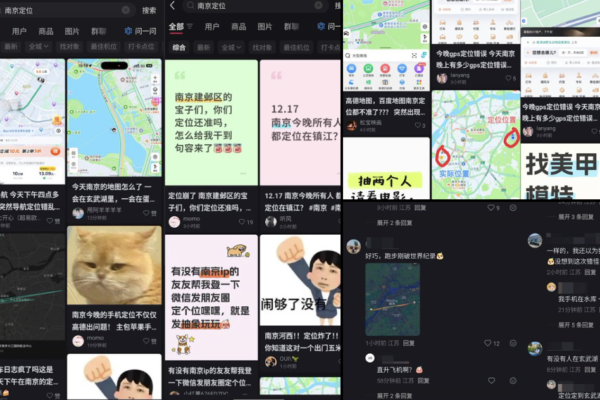
According to reports from mainland Chinese media, on the afternoon and evening of December 17th, several navigation software systems in Nanjing, Jiangsu Province experienced sudden abnormalities. Popular apps such as Baidu Maps, Gaode Maps, and Tencent Maps all malfunctioned simultaneously, affecting food delivery, ride-hailing services, and bike-sharing that rely on location services. This incident sparked widespread concern and discussion among the public.
Many netizens complained about inaccuracies in common navigation apps, with issues such as incorrect positioning and navigation routes. Delivery workers were heavily impacted, as the built-in navigation on platforms like Meituan and Taobao’s Flash Purchase also went awry. Ride-hailing and taxi drivers lamented about inaccurate and fluctuating positioning, making it impossible to efficiently accept orders.
This rare collective navigation malfunction lasted until late night on the same day before gradually returning to normal. Some netizens speculated that during the cross-strait entrepreneurs summit annual meeting held in Nanjing from the 16th to the 17th, high-security measures were in place. To prevent security risks like drone intrusion during the crucial period when the summit was concluding and important figures were leaving on the evening of the 17th, it is believed that satellite signal interference measures were activated, leading to abnormal satellite signals in the vicinity.
Official media reports stated that the cross-strait entrepreneurs summit annual meeting took place in Nanjing from the 16th to the 17th, with Wang Huning, member of the Political Bureau of the CPC Central Committee and Chairman of the National Committee of the Chinese People’s Political Consultative Conference, attending the opening ceremony on the 16th.
The Nanjing Satellite Application Industry Association released a technical analysis titled “Technical Exploration and Analysis of Abnormal Navigation Signals in the Nanjing Region,” stating that the core reason for the navigation malfunction was the suppression of GNSS (Global Navigation Satellite System) satellite signals (including Beidou and GPS) due to temporary interference, not a disruption in network signals. The interference was accurately targeted at the civilian frequency bands of Beidou and GPS, rendering the positioning signals unidentifiable to receivers.
The Nanjing Satellite Association subtly indicated that if the navigation abnormalities were temporary signal control measures required for major event security, they would fall under conventional safety measures in the industry, and the related signals have gradually returned to normal post-event. The analysis by the association was labeled as the “public disclosure of the reasons behind the collective navigation malfunction in Nanjing,” though the association did not specify the source of the interference. As of the deadline, there was no official response to the incident.
Regarding this incident, discussions on social media platforms speculated about potential future scenarios where internet, GPS, and communication services could be disrupted during a conflict, leaving only essential services like energy and healthcare operational. This incident highlights the limitations of offline maps in resolving core issues like malfunctioning navigation systems, emphasizing that map data does not equate to positioning accuracy.
The interference with satellite signals remains a primary method used by the Chinese government for strict security measures during significant events. In a similar past incident on November 6th and 7th, 2024, during the eighth leadership meeting of the Lancang-Mekong Sub-Regional Economic Cooperation held in Kunming, many netizens reported disruptions in navigation services, including frequent positioning errors and instantaneous drifting. Nearby food delivery workers were mistakenly located in Dianchi Lake, causing a backlog of undelivered orders. Gaode Maps responded, attributing the issues to non-product-related factors.
During that time, some netizens on overseas social media platforms claimed that the disruptions were due to enhanced security measures by the Chinese authorities during the meeting, speculating the deployment of signal jammers in the vicinity.