
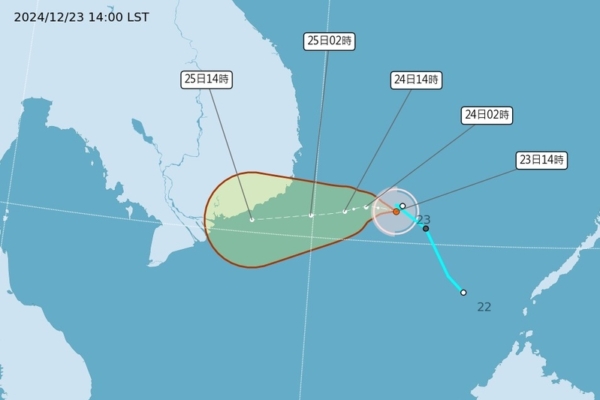
Taiwan’s Central Weather Bureau issued a typhoon formation message today (23rd), stating that a tropical depression which was originally located in the waters near Nansha Island developed into this year’s 26th typhoon, named Pabuk (internationally known as PABUK) at 2 p.m. It is expected to move towards the central and southern peninsula.
The Central Weather Bureau of Taiwan reported that the mild Typhoon Pabuk, designated as PABUK internationally, had its center position at 11.0 degrees north latitude, 112.7 degrees east longitude at 2 p.m. today, moving west at a speed of 11 kilometers per hour. The central pressure is 1,000 hPa, with maximum sustained winds near the center at 18 meters per second and gusts up to 25 meters per second. The radius of strong winds (level 7) averages 80 kilometers (90 kilometers on the northwest side, 70 kilometers on the northeast side, 90 kilometers on the southwest side, and 70 kilometers on the southeast side).
In a statement released in a media group chat, the Central Weather Bureau informed that Typhoon Pabuk was formed at 2 p.m. today and is expected to move towards the central and southern peninsula, posing no direct threat to Taiwan. The bureau also issued a strong wind warning for the land, noting that the northeast wind is significantly strong with the possibility of strong gusts of wind of levels 9 to 10 in Hengchun Peninsula. There may also be strong gusts in open coastal areas from Taoyuan to Yunlin, as well as in Lanyu, Green Island, Penghu, and Matsu. People are advised to be cautious as the adjacent sea areas may experience large waves.
Associate Professor Wu Derong from the Department of Atmospheric Sciences at Taiwan Central University mentioned on “Sanliun’s On-the-Mark Meteorology” that the latest European model (ECMWF) simulation shows that the middle-level clouds of the tropical depression in the South China Sea moved in from the west, increasing cloud cover in various places. The western part of Taiwan might experience scattered showers, while the eastern part could see brief showers with the arrival of the northeast wind. The cold air is gradually weakening, leading to a slight increase in temperature.
Wu Derong further explained that according to the latest simulation, on the 24th, the middle-level clouds will gradually move away to the southeast, improving conditions first in the northern part of the western region and then in the southern parts. The eastern part may still experience brief showers, but temperatures will continue to rise. The weather will noticeably warm up on the 25th with clear to partly cloudy skies in various places. There may be occasional brief showers in the eastern part. On the 26th, another frontal system will move southwards, causing localized brief showers in Greater Taipei and the eastern region. The strong cold front will move southwards after the 27th, leading to a gradual drop in temperature. Northern Taiwan will become increasingly cold and wet. On the 28th, the damp and cold weather will transition to dry and cool, and by the 29th, it will be sunny and dry everywhere.
He cautioned that the latest European and American model simulations indicate a high probability of this cold air mass being a “continental cold air mass,” but due to strong “radiative cooling,” lower temperatures may occur. Models will continue to be fine-tuned, and continuous monitoring is advised. From the 30th to the 31st, temperatures will noticeably rise in various places, with warm and stable conditions during the day and large temperature differences between day and night. On January 1st next year, another “northeasterly monsoon” is expected to move southwards with weaker cold air, resulting in brief showers against the wind and cooler temperatures in northern Taiwan.