
Taiwan’s Central Weather Bureau issued a medium typhoon warning for Typhoon Usagi in the early hours of the morning on the 14th, with a chance of the storm’s violent winds reaching land on the 15th. The exact location for potential landfall and the specific trajectory are still uncertain, as various countries’ forecast models differ significantly at this stage.
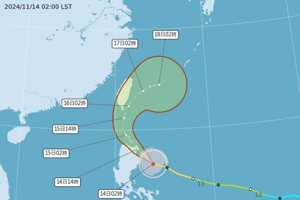
At 2 a.m. today, Typhoon Usagi’s center was at a latitude of 16.6 degrees North and a longitude of 123.9 degrees East, moving at a speed of 18 kilometers per hour in a northwest direction. The central pressure was 945 hPa, with maximum sustained winds near the center at 45 meters per second and gusts reaching 55 meters per second. The radius of gale-force winds extended 150 kilometers, while the radius of storm-force winds spanned 50 kilometers (60 kilometers to the northwest, 60 kilometers to the northeast, 40 kilometers to the southwest, and 40 kilometers to the southeast).
In an update on Facebook, the Central Weather Bureau announced a marine typhoon warning at 8:30 a.m., with Typhoon Usagi’s center at a latitude of 17.2 degrees North and a longitude of 123.1 degrees East at 8 a.m., approximately 570 kilometers south-southeast of Eluanbi. The typhoon was moving at 18 kilometers per hour in a northwest to north-northwest direction. Latest data showed that Typhoon Usagi’s center was in the sea to the south-southeast of Eluanbi, moving in a north-northwest direction, posing a threat to the Bashi Channel.
Areas under sea alert: vessels in the Bashi Channel should exercise caution. There is a likelihood of high waves along the eastern and southwestern coast, the Hengchun Peninsula, Penghu, Orchid Island, and Green Island. The seas off eastern and southeastern Taiwan, and the Bashi Channel, are expected to experience increasing winds and waves. Strong gusts are likely along the northern coast of Keelung, the Hengchun Peninsula, and Matsu today, with strong gusts forecast for the Hengchun Peninsula and Orchid Island in the early hours of the 15th, reaching levels of 8 to 9.
At a press conference at 8:40 a.m., Weng Wan-Hua, a meteorologist at Taiwan’s Central Weather Bureau, stated that the factors influencing Typhoon Usagi during the autumn are quite complex. Therefore, the impact of the typhoon’s movement near Taiwan on the weather can be highly variable. The current forecast suggests that the typhoon will move in a northwestern direction today towards the Bashi Channel before turning north-northeast and gradually shifting towards the northeast, bringing it closer to Taiwanese land than initially predicted on the 13th. The exact location and timing of possible landfall remain uncertain, with significant disparities among countries’ projections making it too early to determine.