
Taiwan’s Central Weather Bureau issued a maritime typhoon warning for Typhoon Kong-Rey at 5:30 pm today (29th). The typhoon is expected to strengthen in intensity, with a trend of the wind radius expanding.
According to the Central Weather Bureau, at 2 pm today, the center of Typhoon Kong-Rey was located at 17.8 degrees north latitude, 126.6 degrees east longitude, moving northwest at a speed of 17 kilometers per hour. The central pressure was 950 hPa, with maximum sustained winds near the center at 40 meters per second and maximum gusts at 50 meters per second. The radius of 7-level wind with average strong winds extends up to 280 kilometers, and the radius of 10-level wind extends up to 90 kilometers (90 kilometers in the northwest, northeast, southwest, and southeast directions).
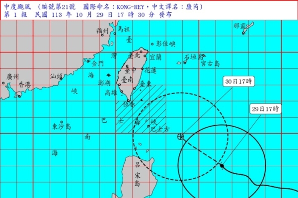
The Central Weather Bureau stated that the moderate typhoon Kong-Rey (international name KONG-REY) at 5 pm was located at 18.0 degrees north latitude, 126.4 degrees east longitude, approximately 720 kilometers southeast of Eluanbi, moving northwest at a speed of 14 kilometers per hour.
Regarding the dynamics of Typhoon Kong-Rey, the Central Weather Bureau indicated that based on the latest data, Typhoon Kong-Rey has slightly strengthened in the past 3 hours. Its center is currently located at the southeast sea area of Eluanbi, moving northwest, posing a threat to the Bashi Strait and the southeastern sea area of Taiwan. The typhoon is expected to intensify in the future with an expanding wind radius.
The Central Weather Bureau announced the maritime warning areas and measures: vessels navigating and operating in the southeastern sea area of Taiwan (including Orchid Island, Green Island), and the Bashi Channel should be on high alert. Long-period swells are likely to occur in coastal areas of Taiwan, Orchid Island, Green Island, Penghu, Kinmen, and Matsu, with gradually increasing waves in these areas and the Bashi Channel.
Strong wind alerts on land: Noticeable strong northeasterly winds are expected today, with Orchid Island likely to experience strong gusts of 10 to 11 Beaufort scale, and open coastal areas from Taoyuan to Yunlin and the Hengchun Peninsula, Green Island, and Penghu may experience gusts of 9 to 10 Beaufort scale. Matsu will also have strong gusts of 8 to 9 Beaufort scale, while the northern coast of Keelung, eastern and southeastern coastal areas, and Kinmen will experience relatively strong winds.
The Central Weather Bureau mentioned that on the 30th, the outer circulation of the typhoon will bring strong gusts of 11 to 12 Beaufort scale to Orchid Island, Green Island, and Penghu. Coastal areas north of Tainan, the Hengchun Peninsula, and Matsu will experience strong gusts of 9 to 10 Beaufort scale, particularly in the open coastal areas from Miaoli to Yunlin with gusts around 11 Beaufort scale. The eastern coastal areas and Kinmen will also experience relatively strong winds, with larger waves in adjacent waters.