
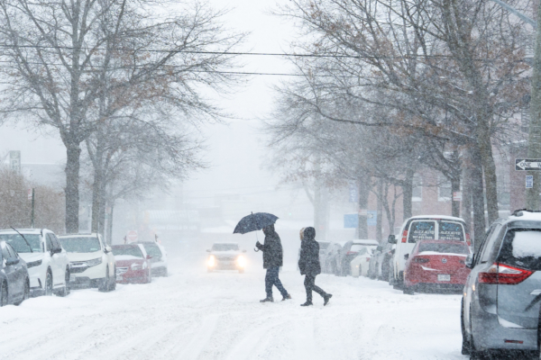
Weather.com meteorologist Jonathan Erdman stated on Friday that a Nor’easter is expected to hit the East Coast of the United States this weekend, although it is currently difficult to accurately predict the amount of snowfall and the areas where it will occur.
“This potential Nor’easter’s path is still uncertain, so from Sunday to Monday, the impacts of snowfall, rain, strong winds, and coastal flooding from New England to the Mid-Atlantic states remain uncertain,” he said.
A Nor’easter, also known as an East Coast low-pressure system, is a strong storm unique to the northeastern United States, named for its prevailing winds blowing from the northeast toward land, often bringing heavy snow or rain during the winter.
According to AccuWeather, this storm could rapidly intensify, bringing greater snowfall to some areas along Interstate 95, including New York City and Philadelphia.
AccuWeather’s Vice President of Forecasting Operations, Dan DePodwin, said, “Whether the snowfall along Interstate 95 will be significant or not depends on the path of the coastal storm, which will be determined by how quickly the storm strengthens.”
The National Weather Service in Philadelphia stated in an online forecast discussion earlier on Friday that the forecast should become clearer soon, “By later tonight, the total snowfall and duration of the blizzard should become more defined.”
The Stirling Weather Forecast Office in Virginia stated in an online forecast, “We are still in the ‘wait and see’ stage, regardless of the storm outcome, it is important to urge the public to stay vigilant, take preventive measures, in case the worst-case scenario happens.”
Erdman expects the highest snowfall in coastal areas from New Jersey to Massachusetts, with total snowfall potentially exceeding 4 inches (10 centimeters); northern regions of the Appalachian Mountains could see snowfall exceeding 1 foot (30 centimeters).
AccuWeather predicts that from Washington D.C. to Philadelphia, New York City, and Boston, precipitation (including rain, snow, hail, etc.) will mainly appear in the form of snow, but due to temperatures hovering around freezing, significant snow accumulation may be difficult to see on paved surfaces like roads during the day.
DePodwin mentioned, “Although there won’t be heavy snow during the daytime on Sunday and Monday, due to temperatures near freezing and the higher sun angle by late February, some sections of highways and city streets may be more slippery or muddy.”
He added, “At times, the snowfall can be heavy, especially during nighttime.”
(This article referenced reporting from USA TODAY)