
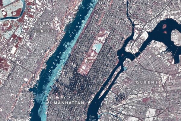
In late January, the metropolitan area of New York City in the United States was affected by a persistent cold snap. Satellite images from the National Aeronautics and Space Administration (NASA) showed that the Hudson River on the west side of Manhattan has frozen over.
NASA released images of New York City taken by the Operational Land Imager of its Landsat 8 observation satellite on January 28. The images depicted the winter scenery of the city.
The image was processed with false colors to differentiate ice (light blue), open water, snow cover, and vegetation in red.
Extensive ice cover was observed on the Hudson River. Some ice cover was also visible on the East River, the Jacqueline Kennedy Onassis Reservoir in Central Park, and waterways in the state of New Jersey.
The temperature in New York City dropped below freezing on January 24 and remained so for over a week. On the day the image was taken (January 28), the highest temperature in the city was 23 degrees Fahrenheit (approximately -5 degrees Celsius). During this time, much of the eastern United States experienced low temperatures and bitter cold winds due to the influence of Arctic air currents.
Most of the ice seen in the image likely drifted downstream. The lower tidal flow and lower salinity upstream make the water there more prone to freezing than the faster-flowing, higher salinity water near the river mouth, with higher freezing temperatures.
While experts suggest the likelihood of a complete freeze of the Hudson River near Manhattan is low, such an event did occur in 1888, causing enough ice accumulation to halt ferry services in New York City for several days.
Frozen rivers can have various impacts, from flooding and infrastructure damage to alterations in hydrological processes, which can affect water quality and aquatic habitats.
Scientists, government agencies, and emergency responders are increasingly utilizing remote sensing technologies like hyperspectral imaging to monitor ice conditions in rivers. Enhanced monitoring mechanisms aid in water resource management and mitigate the impacts of ice on infrastructure and ecosystems.
Aside from ice on the river surfaces, other winter scenes are also visible across New York City. Following a winter storm, the ground was blanketed with fresh snow. A weather station in Central Park recorded nearly 12 inches of snow on January 25. In Midtown and Downtown Manhattan, the low angle of the winter sun cast long shadows from tall buildings.
On February 2, Chuck the groundhog at the Staten Island Zoo in New York City saw his shadow, indicating six more weeks of winter. Chuck is renowned for predicting the weather and is believed to have a higher accuracy rate compared to other animal “meteorologists,” according to folklore and the zoo.
This year, Chuck’s prediction may be on point, at least in the short term. The National Weather Service forecasts temperatures to remain below average, with Arctic cold air set to return to New York City over the weekend.