
The majority of the United States has recently been blanketed by heavy snowfall due to winter storms, creating a picturesque white landscape. However, the snowfall in the western part of the country has been unusually low. Satellite images released by the National Aeronautics and Space Administration (NASA) reveal that multiple states in the western region are currently facing a severe snow drought.
According to NASA’s press release on January 29, the snowpack in the western mountainous areas of the U.S. remains thin at the beginning of this year. Despite above-average or average precipitation levels during the fall and early winter in most areas, the warmer temperatures have caused the majority of the precipitation to fall as rain instead of snow. This has resulted in significantly low snow accumulation, leading to the phenomenon of snow drought.
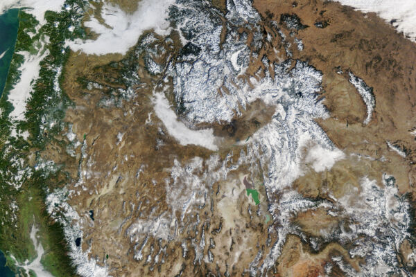
On January 15, NASA’s Terra satellite captured images showing sparse snow cover in the western U.S. region using the Moderate Resolution Imaging Spectroradiometer (MODIS).
Satellite observation data indicates that the snow cover in the western region only encompassed 142,700 square miles (369,700 square kilometers). This marked the lowest recorded snow cover area on that date since MODIS began collecting data in 2001, at less than a third of the median. By January 26, there was a slight increase in snow cover area.
In addition to snow cover area, snow water equivalent (SWE) – the amount of water stored in the snowpack – is also an important indicator of winter conditions in the western U.S.
Data released by the National Integrated Drought Information System in early January revealed that snow drought conditions (defined as SWE below the 20th percentile for a specific date) were most severe in Washington, Oregon, Colorado, Utah, Arizona, and New Mexico.
According to the information released by the Natural Resources Conservation Service of the U.S. Department of Agriculture, as of January 26, at least one ground monitoring station in major watersheds in the west recorded the lowest SWE in at least 20 years.
Overall, the western region of the U.S. has experienced abnormally wet and warm conditions in the preceding months. During the water year starting on October 1, 2025, precipitation in many areas met or exceeded average values. However, record-high temperatures in the region led to most precipitation falling as rain rather than snow.
In the southern Sierra Nevada and northern Rocky Mountains, there were slight differences in snowfall amounts, with higher elevations receiving more snow than rain. While some high-altitude areas had above-average SWE, the SWE at lower elevations was lower.
Climate scientist Daniel Swain from the California Institute for Water Resources noted in a report that the insufficient snowpack is a typical consequence of climate change and temperature variations correlated with altitude.
Rain often runs off before replenishing reservoirs and groundwater, whereas winter snowmelt can provide a more stable and lasting water source once spring arrives. The health of mountain snowpack is crucial for ecosystems, wildfire dynamics, and water supply for agricultural and other purposes during drier periods of the year.
Winter is not yet over, and significant snowfall may occur in February and March. However, the amount of snowfall in the coming months may not be enough to offset the current lack of snow. In regions already experiencing drought, such as the Pacific Northwest and Colorado River Basin, insufficient snowfall could worsen or lead to traditional drought conditions.