
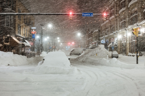
A widespread and powerful winter storm is set to sweep across the United States this weekend, bringing heavy snow and dangerous icy conditions to multiple states. New York City and the Tri-State Area have already issued winter storm warnings, with the alert set to continue until the evening of January 26.
Meteorologists forecast that this storm will bring continuous snowfall to New York City and surrounding areas throughout Sunday, with periods of intense snowfall that may extend into early Monday morning.
According to the latest predictions, areas farther north and west of New York City could see even more significant snowfall, including northwestern New Jersey, the Hudson Valley, and eastern Pennsylvania, with accumulations possibly exceeding 12 inches, and in some areas approaching 18 inches.
Within New York City itself, Long Island, and most of New Jersey, snowfall is expected to range between 8 to 12 inches.
The forecast indicates that snowfall will begin on Sunday morning, peak around midday, and in the afternoon, some areas may see a mix of rain and snow or freezing rain. Snowfall will continue into the evening but will gradually taper off in intensity. Sporadic snow showers may still occur on Monday, primarily light snow, accompanied by low temperatures.
Facing what could be the most severe winter storm in years, governments at all levels in the Tri-State Area have elevated their preparedness status, and residents have been stocking up on food and essentials in anticipation of the weather.
New York Governor Ho Chu has declared a state of emergency statewide to mobilize resources for dealing with the snowstorm and its impact on transportation.
The Metropolitan Transportation Authority (MTA) has issued warnings that the blizzard may affect the subway, buses, Long Island Rail Road (LIRR), Metro-North, and Access-A-Ride services. The MTA advises citizens to avoid unnecessary travel on Sunday and Monday and to stay informed about current traffic conditions before heading out, exercising extra caution.
Meteorologists note that this winter storm is not confined to the Northeastern United States but spans across a vast region of the country, from the Midwest to the East Coast, with multiple states simultaneously facing threats of heavy snow, ice, and strong winds. Snow and freezing rain in certain areas may severely disrupt roadways, air travel, and power systems, prompting federal and state agencies to closely monitor the situation.
The U.S. National Weather Service describes this as a “broad-reaching, impactful” winter weather system, reminding residents across the affected regions to stay vigilant with the latest weather alerts, prepare in advance for cold, slippery conditions, and potential power outages.