
Taiwan’s Central Weather Bureau announced that Typhoon Kangray is still intensifying and expanding. It is estimated that a marine warning will be issued by this evening (October 29). Taiwan’s meteorological expert Wu Derong stated that there is a high probability of Typhoon Kangray making landfall, warning of severe winds and heavy rain.
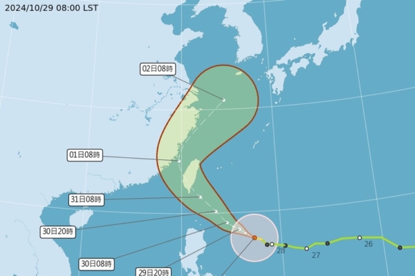
As of 8 a.m. on the 29th, the central position of the typhoon was at 17.5 degrees north latitude and 127.3 degrees east longitude, moving northwest at a speed of 20 kilometers per hour. The central pressure is 965 hPa, with maximum sustained winds near the center at 35 meters per second and gusts up to 45 meters per second. The radius of strong winds extends up to 250 kilometers, and the radius of gale-force winds is 80 kilometers.
Forecaster Zhu Meilin from Taiwan’s Central Weather Bureau stated that Typhoon Kangray is predicted to reach a mid-range intensity, with a high chance of making landfall in the eastern part of Taiwan. A marine typhoon warning is expected to be issued by this evening, with a land typhoon warning likely on the morning of the 30th.
At Taiwan’s Central University’s Department of Atmospheric Sciences, associate professor Wu Derong discussed the forecast for Typhoon Kangray. Recent official predictions indicate that the typhoon has shifted north near the Ryukyu Islands and is now moving towards the east of Taiwan. The latest forecast suggests that it will make landfall in the eastern part of Taiwan.
According to Wu Derong, European models also show a similar trend, with some models indicating a southern path towards southern Taiwan. However, the uncertainty range in the predictions of the US, Japan, and Taiwan includes Taiwan and neighboring waters, suggesting a possibility of further southward adjustments in the forecasted path.
Wu Derong emphasized the potential threat posed by Typhoon Kangray, with sustained winds reaching up to 48 meters per second near the center, which is the upper limit for a mid-level typhoon. The likelihood of it intensifying into a severe typhoon cannot be ruled out, indicating a significant threat that should not be underestimated. The official path forecasts suggest that Typhoon Kangray may make landfall on October 31.
Regarding the weather impact, Wu Derong stated that on October 30, the northeastern monsoon and the outer circulation of Typhoon Kangray will bring prolonged and heavy rainfall to the northern and northeastern regions, with showers in the east. Central and southern areas are expected to be partly cloudy with some rain showers.
Looking ahead to October 31 and November 1, the impact of Typhoon Kangray is expected to be significant, bringing strong winds and heavy rain. The point of landfall, along with the destructive winds of the eyewall, poses a serious threat to Taiwan and requires early preparedness measures from the public. The magnitude of wind and rainfall will be closely linked to the path of the typhoon, and citizens are advised to pay attention to the warnings issued by the meteorological bureau. By November 2-3, as Typhoon Kangray moves away, the weather is expected to improve, but residual moisture may still bring sporadic rainfall.