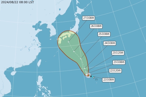
On August 22, 2024, according to Taiwan’s Central Weather Bureau, a low-pressure system near Guam developed into the 10th typhoon of the year, named “Shanshan,” moving towards Japan and not expected to impact Taiwan. Weather experts in Taiwan predict a high probability of Typhoon Shanshan affecting Japan in the future.
Typhoon “Shanshan,” categorized as a mild typhoon and designated as the 10th typhoon of the year (internationally named SHANSHAN), had its center position located at 17.0 degrees north latitude and 141.8 degrees east longitude at 8 a.m. today. It is moving at a speed of 6 kilometers per hour in the north-northwest direction. The central pressure is 995 hPa, with the maximum wind speed near the center at 20 meters per second and maximum gusts at 28 meters per second. The radius of strong winds extends up to 100 kilometers (80 kilometers to the northwest, 120 kilometers to the northeast, 80 kilometers to the southwest, and 120 kilometers to the southeast).
According to the Taiwan Central Weather Bureau, Typhoon Shanshan was located 2,340 kilometers southeast of Gueishan Island at 2 a.m. today, moving in a north-northwest direction towards Japan, having no impact on Taiwan’s weather.
Associate Professor Wu Derong from the Department of Atmospheric Sciences at National Central University in Taiwan mentioned on SETN Weather Forecast today that Typhoon Shanshan is expected to move slowly in the next 2 days. After the weakening of the high-pressure system to the north, it is likely to be guided by the high pressure on its east side, moving towards Japan in a north-northwest direction with a tendency to intensify to at least a moderate level.
Wu Derong pointed out that the latest European model (ECMWF) ensemble simulations as of 8 p.m. on the 21st show a consistent path for the first 5 days, but there is a high probability of the typhoon turning northeastwards later, potentially impacting Japan. However, there is significant “uncertainty” regarding the landing location and timing, requiring further observation. From August until now, six typhoons have formed in the northwest Pacific, surpassing the climatological average for August (5.4 typhoons).
The Central Weather Bureau of Taiwan reported that the weather today is hot, with Taipei City, New Taipei City, Miaoli County, and Taitung County under an orange heat warning, with a high probability of reaching 36 degrees Celsius around noon. Pingtung County is under a yellow heat warning. It is advised to avoid unnecessary outdoor activities, labor, and exercise, apply sunscreen, stay hydrated, and be cautious of heat stroke. Ensure indoor spaces are well-ventilated and cool, and consider methods to lower body or environmental temperature, such as using fans or ice packs. People working or exercising outdoors should stay away from high-temperature environments.
Wu Derong mentioned that the latest European model (ECMWF) simulations at 8 p.m. on the 21st indicated that due to the influence of the “Pacific high-pressure system” today and on the 23rd, the heat will be intense resembling midsummer, requiring precautions against sunburn and heatstroke. In the afternoon, there is a chance of localized brief showers or thunderstorms in mountainous areas and some parts of northern Taiwan. From the 24th to the 28th, the “Pacific high-pressure system” will weaken, resulting in continued hot weather. However, with increased moisture, there may be a growing trend of localized thunderstorms in the afternoon, affecting a wider area of the plains near mountainous regions.

