
Summer is the peak season for the formation of tropical storms such as hurricanes and typhoons, and every year, disasters often occur, attracting significant attention from people. However, have you ever noticed that when meteorological bureaus present the projected paths of these tropical storms, they never seem to mention any hurricanes or typhoons crossing the equator, traveling from the Southern Hemisphere to the Northern Hemisphere or vice versa? Why is that?
According to a report by the British Broadcasting Corporation (BBC), hurricanes, typhoons, and cyclones are all tropical storms but are referred to by different names depending on the region. Tropical storms forming in the North Atlantic, central North Pacific, and northeast Pacific are called hurricanes; those originating in the northwest Pacific are known as typhoons, while in the South Pacific and Indian Ocean, they are referred to as cyclones.
The National Oceanic and Atmospheric Administration (NOAA) in the United States states that once a tropical storm reaches a sustained maximum wind speed of at least 74 miles per hour (about 119 kilometers per hour), it is classified as a hurricane, typhoon, or cyclone, with the specific name depending on where the storm formed.
As for the naming of these tropical storms, multiple names are provided by various countries, leading to extensive naming lists where newly occurring typhoons are named accordingly in a cyclical manner.
Due to the significant damages caused by Typhoon Haiyan in 2013 and Hurricane Katrina in 2005, they have been removed from the naming lists and are no longer used.
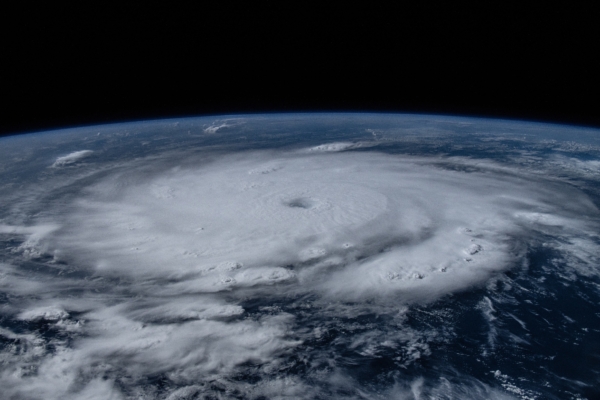
Reported by the Associated Press, the reason tropical storms do not cross the equator is due to the meteorological principle related to the Earth’s rotation – the Coriolis force. This force, an inertial force, causes winds in the Northern Hemisphere to deflect to the right and winds in the Southern Hemisphere to the left.
Alex DaSilva, the Chief Hurricane Specialist at AccuWeather, stated: “It is this force that gives tropical systems their characteristic swirl – counterclockwise rotation in the Northern Hemisphere and clockwise rotation in the Southern Hemisphere.”
This means that tropical storms in the Northern Hemisphere rotate counterclockwise, while those in the Southern Hemisphere rotate clockwise. However, at the equator, the Coriolis force is almost zero, very weak, and insufficient to create or sustain the rotation of tropical storms. Therefore, tropical storms cannot form near the equator and are unable to cross between the Northern and Southern Hemispheres.
Most tropical storms form north of 5 degrees latitude or south of 5 degrees latitude. To date, the tropical storm closest to the equator was Typhoon Haima in the western Pacific in December 2001, which formed at 1.4 degrees north, less than 100 miles (161 kilometers) from the equator.
The closest tropical depression to the equator was an unnamed storm formed in December 1973. This storm formed at 0.5 degrees north and, according to the China Meteorological Administration, later developed into a tropical storm around 0.7 degrees north.
However, the National Hurricane Center in the United States does not agree with this official record. According to the Center’s data, tropical storm strength wind speeds only appear when the system reaches northern latitudes above 10 degrees. This discrepancy in measurement may be due to the different methods used by these two organizations to assess the wind force of tropical systems.