
Taiwanese meteorologists have stated that according to the latest European model simulation, today (21st) will be affected by the seasonal circulation, with chances of scattered showers or thunderstorms in various regions. The eastern part will continue to experience relatively heavy rainfall, with the need to be alert for consecutive days of rainy weather leading to disasters.
The Taitung County government has announced that due to the impact of the typhoon’s peripheral circulation, the southern part of Taitung is experiencing heavy rainfall, increasing the risk of disasters. To ensure the safety of people’s movements, Dawu, Taimali, Daren, and Jinfeng townships have suspended work and classes today. The county government has urged residents to be cautious of disasters such as landslides and to guard against flooding in low-lying areas.
Associate Professor Wu Derong from the Department of Atmospheric Sciences at National Central University in Taiwan mentioned in the “Weather Machine Classroom” column of the Meteorological Application Promotion Foundation that the latest European model (ECMWF) simulation at 8 p.m. on the 20th showed that today, affected by the seasonal circulation, there will be high moisture content and unstable atmosphere, leading to chances of scattered showers or thunderstorms in various regions. The eastern part will still experience relatively heavier rainfall. Temperatures across different regions will range from 24 to 30 degrees Celsius in the north, 24 to 34 degrees Celsius in the central region, 24 to 33 degrees Celsius in the south, and 24 to 30 degrees Celsius in the east.
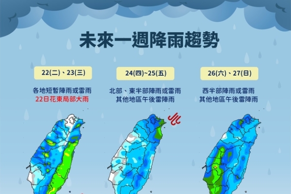
Wu Derong stated that the latest model simulation indicates that on the 22nd and 23rd, the area will still be within the seasonal circulation, with unstable atmosphere. The eastern part will see significant rainfall, while the western mountainous areas may experience isolated showers or thunderstorms in the afternoon, with a chance of expanding to the plains as well. Weather changes starting from the 24th will be related to the movement of the seasonal circulation and the development of tropical systems within it, indicating a pattern of increased rainfall, requiring continued monitoring of the distribution of precipitation.
On the early morning of the 21st at 2 a.m., the Meteorological Bureau’s “Path Potential Prediction Map” showed that Typhoon Vipa would bring strong winds and heavy rain to the coast of Guangdong in the morning, passing through the Leizhou Peninsula in the afternoon and entering Tokyo Bay, then making landfall in northern Vietnam on the evening of the 22nd.
The latest European ensemble model (ECMWF) indicates that as of 8 p.m. on the 25th, the probability of invasion depicted in the “tropical system” map shows a 70% chance of it turning north over the eastern Taiwan sea area, with the likelihood of it hitting northern Taiwan dropping to around 30%. The simulation map at 2 a.m. on the 25th shows a loosely structured “tropical system” with its extensive circulation merging with the seasonal circulation, carrying a large amount of moisture and posing a significant threat of rainfall that should not be underestimated.