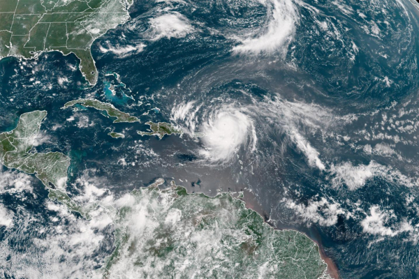
Hurricane Erin, the first hurricane of the Atlantic hurricane season this year, is currently moving north along the west coast of the Atlantic Ocean. Known as the “Hurricane Hunters,” the 53rd Weather Reconnaissance Squadron of the United States Air Force recently sent aircraft into the eye of the hurricane and captured a rare and stunning image of a clear and cloudless sky.
The squadron posted on social media platform X on August 16th, saying: “Last night, the 53rd Weather Reconnaissance Squadron flew into the eye of Hurricane Erin and captured amazing images with a stadium-like effect.”
According to the squadron, these missions provide crucial data for the National Hurricane Center (NHC) in improving the accuracy of weather forecasts and ensuring community safety before storms make landfall.
The images captured by the squadron show a vast expanse of white surroundings as the aircraft flies within the eyewall. However, upon breaking through the eyewall, a blue sky and the sun overhead become visible above the hurricane eye, with the thick eyewall shape clearly defined.
Hurricane Erin strengthened to a Category 5 hurricane on August 16th but later weakened to a Category 4 hurricane. The NHC announced on August 17th that the hurricane had further weakened to a Category 3 hurricane.
Located approximately 330 miles southeast of Grand Turk Island, Hurricane Erin has maximum sustained winds of 125 miles per hour.
The NHC states that on August 17th, Hurricane Erin is moving west-northwest at a speed of nearly 14 miles per hour, with a predicted reduction in forward speed and a turn to the north on August 18th and 19th.
The Associated Press cited senior meteorologist Dan Pydynowski from AccuWeather, stating that including Hurricane Erin, the Atlantic region has seen 43 Category 5 hurricanes to date.
Pydynowski mentioned that while Category 5 hurricanes are rare, the Atlantic region has experienced them for the fourth consecutive year. Conditions required for storms to reach this intensity include very warm sea temperatures, minimal to no wind shear, and being far from land.
The 53rd Weather Reconnaissance Squadron, based at Keesler Air Force Base in Mississippi, is a unique organization and the only combat unit in the world regularly conducting weather reconnaissance missions.
Their mission involves recruiting, organizing, and training specific personnel to conduct aerial weather reconnaissance. They monitor tropical storms and hurricanes in the Atlantic, Caribbean, Gulf of Mexico, and central Pacific for the NHC. Additionally, they perform winter storm missions on both the east and west coasts of the United States.
Equipped with 10 WC-130J aircraft, an upgraded version of the C-130 transport plane, the squadron continues to carry out 21st-century weather reconnaissance with tray-type meteorological data collection instruments.
The basic crew of the WC-130J aircraft includes five members: a pilot, co-pilot, navigator, flight meteorologist, and weather reconnaissance loadmaster.
The pilot and co-pilot control the aircraft, while the navigator tracks the aircraft’s position and movement, monitoring radar to avoid tornadoes. The flight meteorologist acts as the flight director, observing and recording meteorological data at different altitudes. The weather reconnaissance loadmaster uses sensors carried by parachutes to collect and record vertical meteorological data.

