
On Wednesday, July 30th, the United States and India jointly launched a groundbreaking Earth observation satellite equipped with a high-precision radar system. This satellite, named the NASA-ISRO Synthetic Aperture Radar Mission (NISAR), will capture surface changes with unprecedented resolution, bringing about a significant breakthrough in monitoring and early warning for global natural and man-made disasters.
Developed collaboratively by the National Aeronautics and Space Administration (NASA) of the United States and the Indian Space Research Organization (ISRO), NISAR is the first joint satellite project between the two countries. It carries two sets of Synthetic Aperture Radar (SAR) systems provided by the United States and India respectively, scanning the Earth’s surface in different microwave bands to obtain high-resolution images with centimeter-level accuracy.
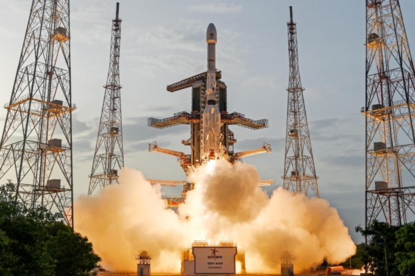
In comparison to traditional optical satellites, NISAR can penetrate cloud cover and rainfall, operating day and night, regardless of weather conditions. The satellite lifted off from the Satish Dhawan Space Centre in India aboard a GSLV-F16 rocket at 8:10 a.m. Eastern Time on July 30th (5:40 p.m. Indian time). It will orbit the Earth 14 times a day, completing repeat scans of most landmasses and ice sheets globally every 12 days and making the data public for global use.
NASA states that the observational data from NISAR will aid in monitoring changes in glaciers, forests, farmland, and permafrost, and enhance human capacity for early warning of earthquakes, volcanic eruptions, floods, and wildfires. Nicky Fox, NASA’s Deputy Director of Science Missions, emphasized the continuous but subtle changes on the Earth’s surface that are difficult to detect with current technology, underscoring the need for better preparedness before, during, and after disasters.
About the size of a pickup truck, NISAR sends and receives radar signals through large antenna reflectors, enabling tracking of terrain deformation and moisture changes, assessment of precursors to volcanic activity, or identification of risks to infrastructure such as levees and dams.
The concept of this mission originated from the National Research Council’s 2007 “Decadal Survey” report, and NASA and ISRO signed a cooperation agreement in 2014. NASA provides the L-band radar and communication subsystem, while ISRO contributes the S-band radar, satellite body, and launch services, with collaboration spanning 13 time zones and 14,500 kilometers.
Karen St. Germain, Director of Earth Science at NASA, described NISAR as a symbol of two democratic countries working together for the global good, emphasizing that it is not just a scientific mission but also a cooperative effort to safeguard the Earth.
Dr. Jitendra Singh, India’s Minister of Science and Technology, highlighted the mission’s demonstration of India’s role as a “World Partner” (Vishwa Bandhu), benefiting not only India and the United States but also providing critical data for global disaster management, agriculture, and climate monitoring.