
The Taiwan Central Weather Bureau stated today (12th) that Typhoon Yangliu is showing signs of strengthening, and is expected to pass over Taiwan on the 13th, with the eastern region being warned against strong winds and the southern region on alert for heavy rain.
At 5:30 am this morning, the Taiwan Central Weather Bureau issued a medium typhoon warning for Typhoon Yangliu at sea, with a forecast to issue a land typhoon warning by noon to afternoon.
According to the Taiwan Central Weather Bureau, Typhoon Yangliu, categorized as a mild typhoon, was located at 20.7 degrees north latitude and 127.8 degrees east longitude at 8 am today, moving at a speed of 22 km per hour to the northwest. The central pressure is 970 hPa, with the maximum wind speed near the center at 33 meters per second and maximum gusts at 43 meters per second. The radius of gale-force winds averages 120 kilometers (140 kilometers on the northwest side, 160 kilometers on the northeast side, 90 kilometers on the southwest side, and 90 kilometers on the southeast side), while the radius of storm-force winds averages 40 kilometers (50 kilometers on the northwest side, 50 kilometers on the northeast side, 30 kilometers on the southwest side, and 30 kilometers on the southeast side).
Associate Professor Wu Derong from the Department of Atmospheric Sciences at Taiwan Central University commented in the “Weather Classroom” column of the Meteorological Application Promotion Foundation that the latest (8 pm on the 11th) European model (ECMWF) simulations indicate that today will still be sunny and hot in various places, prompting the need for sun protection and prevention of heatstroke. There is a slight increase in moisture in the south, with atmospheric instability, leading to a probability of localized showers or thunderstorms in mountainous areas in the afternoon, extending to some low-lying areas.
Wu Derong pointed out that according to the latest European model simulations, Typhoon Yangliu will strike on the 13th. Although its range is small, the eastern and southern regions should guard against significant rainfall disasters, while the eastern region should be prepared for destructive strong winds near the center. It is advised to pay attention to the warnings issued by the weather bureau and enhance typhoon preparedness.
He further mentioned that on the morning of the 14th, Typhoon Yangliu will land in Fujian and gradually weaken in Taiwan. From the 15th to the 18th, the weather will improve across various regions, with high temperatures persisting. However, there will still be a lot of moisture, leading to the possibility of localized showers or thunderstorms in mountainous areas in the afternoon, occasionally extending to some low-lying areas.
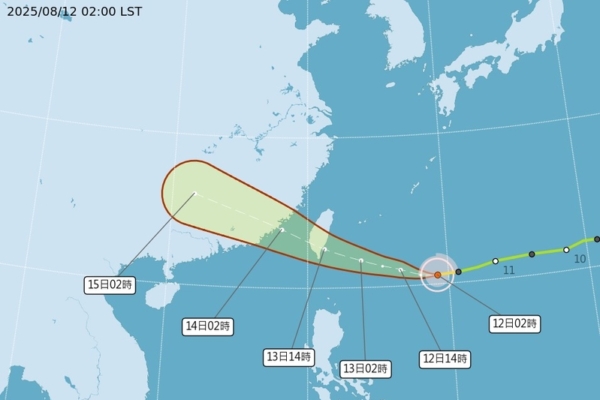
On the early morning of the 12th at 2 o’clock, the “Path Potential Prediction Map” released by the weather bureau and the latest European model ensemble simulations indicate that Typhoon Yangliu will land in Taitung on the 13th at noon and in Fujian on the 14th in the early morning. The ensemble members’ simulated paths are dispersed on both sides, with a convergence in distribution; the simulated intensity before landing is maintained as a mid-typhoon, which will rapidly weaken due to terrain destruction afterward.
Additionally, he warned that due to the inevitable encounter with the destructive strong winds near the landing point, Hualien and Taitung should both strengthen their defenses. The weather bureau’s “Quantitative Rainfall Forecast” suggests that caution should be exercised against significant rainfall disasters in the eastern and southern regions.