
Taiwanese meteorologists today (13th) said that Typhoon Yangliu is gradually approaching Taiwan and is estimated to land near Taitung around noon. Precautions against potential disasters caused by Yangliu are advised for today, with the weather gradually improving on the 14th as the typhoon moves away.
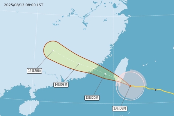
According to Taiwan’s Central Weather Bureau, as of 10:15 am this morning, the latest data indicates that the center of Typhoon No. 11 is currently located southeast of Taitung, moving northwest. Its typhoon circle is gradually entering the southeastern, southern, and eastern parts of Taiwan, posing a threat to Taitung, Hualien, areas south of Miaoli, as well as the Penghu and Kinmen regions.
Associate Professor Wu Derong from the Department of Atmospheric Sciences at National Central University of Taiwan stated today in the “Sky Machine Classroom” column of the Meteorological Application and Promotion Foundation that the latest European model (ECMWF) simulation from 8 pm on the 12th shows that today, Typhoon Yangliu will bring heavy rain to the eastern and southern parts, causing potential disasters. Taitung should be particularly cautious of the destructive strong gusts near the eye of the typhoon and stay alert to the bureau’s warning information.
Wu Derong mentioned that the latest European model simulation indicates that on the morning of the 14th, Yangliu will make another landfall in Fujian and the rainfall in Taiwan will gradually ease. From the 15th to the 17th, the weather will improve with high temperatures, but humidity will still be high, leading to isolated showers or thunderstorms in the mountains in the afternoon, occasionally extending to some low-lying areas. On the 18th and 19th, there will be more moisture and unstable air, causing intense convection in the afternoon, with the possibility of brief localized rainfall at other times.
On the night of the 13th at 2 am, the Bureau’s “Path Potential Prediction Map” showed that Yangliu is expected to land in Taitung around noon today, then make another landfall in Fujian on the morning of the 14th. Before landing in Taitung, it will reach its maximum strength, but rapid weakening will occur due to terrain destruction. As the landing point is expected to encounter destructive strong gusts above level 16, precautions should be taken. The Bureau’s “Quantitative Rainfall Forecast” indicates that precautions against disaster-causing rains should be taken in the eastern and southern parts of Taiwan.