
Taiwanese meteorological experts have indicated that there is a high possibility of Typhoon Yangliu making landfall, with the most intense winds and rain expected on the 13th. According to their analysis based on the European model simulation, the typhoon is estimated to reach Taiwan on the 13th and pass through on the 14th, with a chance of landing in the eastern part of the island. The typhoon is expected to maintain its maximum intensity before landfall, posing a significant threat of strong winds and heavy rainfall that should not be underestimated.
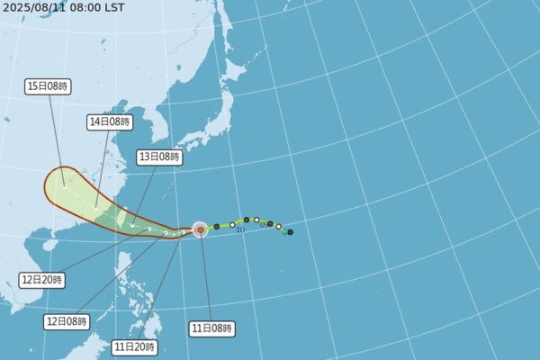
The Central Weather Bureau of Taiwan reported this morning (11th) that the center of the mild Typhoon Yangliu was located at 21.2 degrees north latitude and 133.4 degrees east longitude, moving westward at a speed of 24 kilometers per hour. With a central pressure of 975 hPa, the maximum sustained wind speed near the center is 30 meters per second, with gusts reaching 38 meters per second. The radius of strong winds averages around 120 kilometers (150 kilometers to the northwest, 120 kilometers to the northeast, 100 kilometers to the southwest, and 90 kilometers to the southeast), and the radius of violent winds averages around 30 kilometers (50 kilometers to the northwest, 40 kilometers to the northeast, and 30 kilometers to the southwest).
Associate Professor Wu Derong from the Department of Atmospheric Sciences at National Central University in Taiwan mentioned in the “Heaven’s Machine Classroom” column of the Meteorological Application Promotion Foundation that the latest European model (ECMWF) ensemble simulations project the average path of Typhoon Yangliu to arrive on the 13th and pass through Taiwan on the 14th, with the ensemble paths converging more than before. The simulation indicates that the intensity of the typhoon is expected to be maintained until landfall due to mostly avoiding environments with strong vertical wind shear, and weakening will occur rapidly only after encountering terrain disruption.
Wu Derong explained that the latest “Path Potential Prediction Chart” from the Meteorological Bureau shows a slight southward adjustment in the trajectory of Typhoon Yangliu. The “Violent Wind Circle Invasion Probability Chart” indicates a continuous increase in the probability of violent wind circle invasion to over 80%. Due to the southward adjustment in its trajectory, the typhoon is expected to maintain its maximum intensity before landfall. Although its range is relatively small, the threat of strong winds and heavy rainfall should not be underestimated. People are advised to pay attention to weather warnings and enhance typhoon preparedness.
He further stated that as various country models or official forecasts continue to adjust the projected landing points, Hualien or even further south in Taitung could be potential landing locations for the typhoon, thus close monitoring is necessary.
In addition, Wu mentioned that on the 14th, Typhoon Yangliu is expected to pass smoothly, with the winds and rain gradually subsiding. From the 15th to the 17th, the weather in various regions will improve, although moisture content remains high, leading to localized showers or thunderstorms in mountainous areas during the afternoon, with occasional occurrences spreading to some flatlands.
According to the latest European model simulations, he emphasized that today and tomorrow will continue to be sunny and hot in various regions, urging people to take precautions against sunburn and heatstroke. Southern regions are expected to experience slightly increased moisture content, leading to unstable atmospheric conditions with a probability of localized showers or thunderstorms in mountainous areas during the afternoon, possibly extending to some flatlands.