
Tropical Storm Vipa, the sixth typhoon of this year, formed in the early hours of today (July 18), according to meteorological experts. It is projected that on the 19th and 20th, there will be a high potential for heavy rainfall in the eastern half of Taiwan and Pingtung due to the influence of the typhoon’s outer circulation.
The Central Weather Bureau of Taiwan issued a message stating that a tropical depression previously located in the eastern sea of the Philippines developed into a mild typhoon at 2 a.m. Due to the influence of the typhoon’s outer circulation, there is a probability of wind speeds averaging above 6 on the Beaufort scale or gusts reaching 8 or more in certain areas of Keelung City, New Taipei City, Taoyuan City, Hsinchu City, Hsinchu County, Nantou County, Kaohsiung City, Pingtung County, Yilan County, Hualien County, Taitung County (including Orchid Island and Green Island), Kinmen County, and Lienchiang County (yellow alert). The public is advised to stay vigilant.
According to Wu Derong, an adjunct associate professor at the Department of Atmospheric Sciences at National Central University in Taiwan, the latest European model (ECMWF) as of 8 p.m. on the 17th indicates that today, the western half will have clear skies in the morning with possible showers in the afternoon, remaining hot. Citizens are advised to take precautions against sun exposure and heatstroke. Moisture from the outer circulation of Vipa will move into the eastern half in the afternoon, leading to localized showers. Temperatures across regions will range from 25 to 37 degrees Celsius in the north, 23 to 36 degrees Celsius in the central region, 23 to 36 degrees Celsius in the south, and 23 to 35 degrees Celsius in the east.
Wu Derong further mentioned that on the 19th and 20th, Tropical Storm Vipa is expected to pass through the Bashi Channel, entering the South China Sea. Under the influence of the outer circulation, there will be intermittent showers in the western half, while the eastern half and Pingtung are at risk of experiencing significant rainfall. From the 21st to the 24th, there will be a large amount of moisture brought by the seasonal low-pressure system, coupled with the development and movement of another tropical system within, making Taiwan susceptible to hazardous weather conditions. However, the exact evolution of the situation requires further observation.
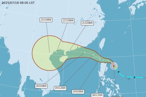
Regarding the projection at 2 a.m. on the 18th, the “Path Potential Forecast Map” from the meteorological bureau showed that Vipa formed at 2 a.m. today. Both the latest European ensemble model (ECMWF) and the simulations from the 18th to the 22nd suggest that the center of Vipa will pass through the Bashi Channel and enter the South China Sea, with a low probability of making landfall in Guangdong, although the issuance of a “marine alert” cannot be completely ruled out.
Additionally, Wu Derong mentioned that various global models between the 21st and 24th show the development of another tropical system within the seasonal low-pressure system, with some simulations indicating a potential serious threat. Statistical analyses from the European ensemble model of 50 simulations showed that the likelihood of northern Taiwan being affected could reach as high as 50%. As models from different countries are continually adjusted, it is advised to closely monitor the situation.