
On October 22, 2024, experts from Taiwan’s meteorological department stated that Typhoon Trami is not expected to strengthen into a severe typhoon. The probability of a direct hit on Taiwan has decreased to below 8%. However, due to the interaction with the terrain, the northern and eastern parts of Taiwan still need to be wary of heavy rainfall.
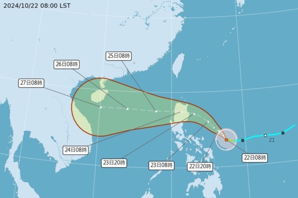
The Central Weather Bureau of Taiwan issued a typhoon alert, reporting that a tropical depression in the seas east of the Philippines has developed into a mild typhoon, named Trami (international designation TRAMI), as of 2 AM today. It is predicted to track in a northwestward direction towards the eastern seas of Luzon Island.
Dr. Wu Derong, an associate professor in the Department of Atmospheric Sciences at National Central University in Taiwan, mentioned in a weather forecast program that latest European model simulations suggest that Trami’s average projected path is towards Luzon Island, in line with the Bureau’s potential trajectory. Although there is uncertainty in individual model paths, the consensus is that Trami is unlikely to intensify into a severe typhoon. The probability of a direct hit on Taiwan has decreased to below 8%.
Dr. Wu further explained that the areas on the outskirts of Trami could still experience significant rainfall due to the uplift caused by the terrain. The effects of the “Autumn Typhoon” are not very pronounced currently due to the delayed southward movement of cold air from the north. However, various model data will continue to be monitored and adjustments made accordingly.
Today, Taiwan is expected to see cloudy skies with occasional short rainfall in the northern coastal areas, eastern Taipei, and the eastern regions. From tonight onwards, rainfall is expected to increase in the northern and northeastern regions, with the strengthening of the northeasterly winds on the 23rd leading to more localized showers. The north will experience damp and cooler weather.
Looking ahead to the 24th and 25th, the outer circulation of Typhoon Trami may bring heavy rainfall to the northern and eastern regions of Taiwan. Special weather advisories should be closely monitored during this period. Wet conditions are expected to persist in the eastern regions on the 26th, with localized showers or thunderstorms in the western parts in the afternoon. By the 27th and 28th, the weather is expected to improve, although residual moisture may still lead to brief showers in some areas.
The Central Weather Bureau of Taiwan stated in a social media post that Typhoon Trami is projected to move towards Luzon Island and the South China Sea, decreasing the likelihood of a direct hit on Taiwan. However, the outer circulation and northeasterly winds may bring significant rainfall and strong winds to windward areas, beginning in the latter half of today with the strengthening of the northeast winds.
The Bureau also warned of increasingly strong coastal winds, particularly along the open coastal areas north of Tainan, the northern coast, the Hengchun Peninsula, and outlying islands, with wind gusts reaching 9 to 11 in some areas, possibly up to 12 in the Hengchun Peninsula and Penghu. Significant waves are expected, reaching heights of 3-5 meters, and even up to 6 meters in Penghu, Green Island, Orchid Island, and the Hengchun Peninsula. It is advised to avoid marine activities and stay updated on the latest ship schedules.
Moreover, the Central Weather Bureau noted that the typhoon’s path may still have some variation as it moves westward, influenced by both northward and southward conditions. This interaction with the northeasterly winds may impact the extent of actual wind and rainfall. Residents in the eastern and northern regions of Taiwan are advised to remain vigilant for the latest weather updates, with Yilan Mountain areas expecting accumulated rainfall from the 23rd and rapid increase in rainfall in the Hualien-Taitung area.