
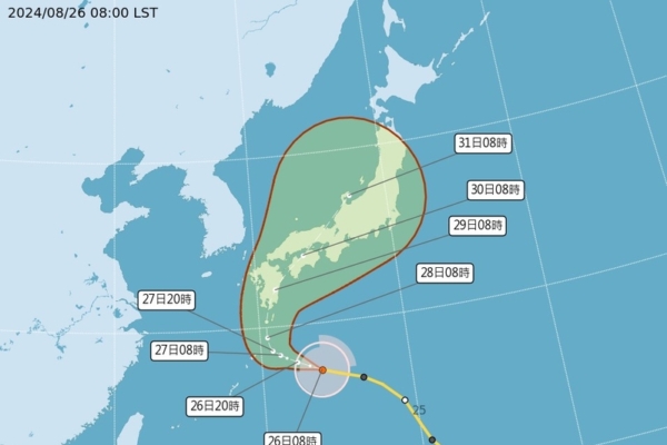
Taiwanese meteorologist Wu Derong stated that the moderate typhoon “Shanshan” may make 2 or 3 landfalls in Japan starting from the 28th, first landing in Kyushu or Shikoku, and then on Honshu. The exact locations are still being adjusted, and the public is reminded to closely monitor the typhoon’s movements if they have travel plans to Japan.
The Central Weather Bureau of Taiwan indicated that as of 8 a.m. on the 26th, the center of Typhoon “Shanshan” was located at 27.2 degrees north latitude, 134.0 degrees east longitude, moving in a northwesterly direction at a speed of 14 kilometers per hour. The central pressure is 960 hPa, with a maximum wind speed near the center of 38 meters per second and maximum gusts of 48 meters per second. The radius of strong winds is 180 kilometers on average (150 kilometers on the northwest side, 230 kilometers on the northeast side, 170 kilometers on the southwest side, and 180 kilometers on the southeast side), while the radius of gale-force winds is 50 kilometers on average (50 kilometers on the northwest side, 60 kilometers on the northeast side, 50 kilometers on the southwest side, and 50 kilometers on the southeast side).
Wu Derong, an associate professor at the Department of Atmospheric Sciences at Central University in Taiwan, mentioned in his column “Sanli Weather Forecast: Big Events in the Sky” today (26th) that Typhoon “Shanshan,” influenced by the Pacific high pressure system, is slightly adjusting westward, moving towards the south of Kyushu, Japan. From the 27th to the 31st, it will make a big turn, shifting northeastward. It is expected to reach its peak on the 27th, weakening gradually on the 28th and 29th due to terrain effect.
According to Wu Derong, the official path prediction charts from various countries at 2 a.m. today indicate that there is a probability of Typhoon “Shanshan” making 2 or 3 landfalls in Japan from the 28th (first in Kyushu or Shikoku, then on Honshu). However, the exact landing locations and timing are subject to continuous adjustments, and travelers with plans to visit Japan should pay close attention to its developments.
Wu Derong also pointed out that the latest European model simulation (ECMWF) from the night of the 25th shows that for the next two days, the “Pacific high pressure system” will weaken but Taiwan will still experience clear and hot weather. People are advised to use sunscreen and prevent heatstroke. In the afternoon, localized thunderstorms may develop in mountainous areas, affecting some flatlands with a chance of localized heavy showers. The temperatures across different regions today range from 23 to 36 degrees Celsius in the north, 23 to 35 degrees Celsius in the central region, 24 to 36 degrees Celsius in the south, and 22 to 35 degrees Celsius in the east.
Wu Derong added that the latest model simulations indicate that from August 28th to September 1st, there will be prevailing southwest and southerly winds, with the weather remaining hot. It is advised to use sunscreen and prevent heatstroke. Convergence with the “land breeze” may lead to brief localized showers in the western half in the early morning, with localized thunderstorms developing in the afternoon near mountainous areas and expanding to some flatlands, with a possibility of localized heavy showers occurring.