
According to the typhoon warning issued by the Central Weather Bureau of Taiwan at 8:30 am, the moderate typhoon Santolo has entered Taiwan with its storm circle. Meteorological experts advise that Typhoon Santolo poses a serious threat to Taiwan and precautions should be taken against catastrophic wind and rain.
The Taitung County government announced on the evening of the 29th that based on the forecast data from the Central Weather Bureau, work and classes in Orchid Island Township will be suspended on the 30th. Other areas will operate as usual.
Professor Wu Derong of the Department of Atmospheric Sciences at National Central University commented on Sanli TV’s weather program that this morning’s infrared cloud image showed Typhoon No. 18 Santolo in the Bashi Channel, continuing to strengthen and expand. The typhoon eye is clearly visible, and the intensity is approaching the upper limit of a medium typhoon.
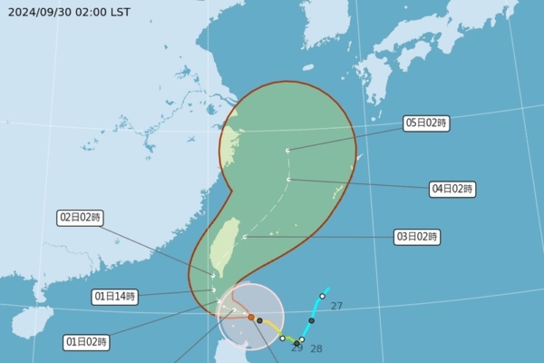
Wu Derong further explained that the latest Central Weather Bureau’s “Path Potential Prediction Map” as of 5 am on the 30th indicates a northwest to north-northeast track, making landfall near Kaohsiung-Pingtung, then heading back out to sea from Hualien. The predicted path still carries “uncertainties.” The latest European model (ECMWF) ensemble simulation map as of 8 pm on the 29th also suggests that the 50 ensemble members are dispersed on both sides of Taiwan, with reduced dispersion, indicating a significantly increased probability of the typhoon’s center making landfall.
Considering the currently projected path by the meteorological bureau, it is estimated that wind and rain will gradually intensify today. The most significant wind and rain is expected on the 1st and 2nd of October, with conditions gradually improving starting from the afternoon of the 3rd. Typhoon Santolo poses significant threats to various regions, especially Pingtung, Taitung, Hualien, and Yilan, where caution should be taken against “catastrophic wind and rain,” with predicted total rainfall potentially reaching up to 1,300 millimeters.
He warned that Greater Taipei and mountainous areas in the western parts should also be vigilant, and other regions should not take the situation lightly. Due to the low-level circulation of Typhoon Santolo being susceptible to strong terrain influences, any unforeseen changes in its trajectory and weather patterns should not come as a surprise. However, the upper-level circulation can maintain the predicted path, traverse terrains, head back out to sea, and restructure into a consistent system. Typhoon Santolo has posed a severe threat to Taiwan, and increased vigilance is advised, under no circumstances should it be underestimated.
According to the typhoon warning issued by the Central Weather Bureau at 8:30 am, the center of the moderate typhoon Santolo at 8 am today was at 20.0 degrees north latitude, 122.1 degrees east longitude, approximately 250 kilometers south-southeast of Guanyin Cape, moving to the northwest-west at a speed of 9 kilometers per hour.
The Central Weather Bureau of Taiwan released dynamic typhoon information, indicating that over the past 3 hours, the intensity of Typhoon No. 18 has slightly increased. The current center is located in the sea southeast of Guanyin Cape, moving northwest-west, and its storm circle has entered the waters near southern Taiwan, posing a threat to Taitung, Pingtung, and the Hengchun Peninsula.
Areas under land alerts: Taitung, Pingtung, and the Hengchun Peninsula should be on high alert. Areas under sea alerts: South Taiwan Strait, southeast waters of Taiwan, Bashi Channel, Dongsha Islands’ waters; navigational and operational vessels should exercise caution.
The Central Weather Bureau of Taiwan stated that today, long waves might occur along the north coast of Keelung, eastern regions (including Orchid Island and Green Island), and the coastal areas of the Hengchun Peninsula. The seas in the eastern region and the Bashi Channel will experience noticeably rough waves, especially with waves exceeding 6 meters in the southeast waters and coastal areas of the Hengchun Peninsula. Waves are expected to gradually increase in other sea areas near Taiwan, thus, activities near the coast should be avoided.
Strong wind alerts on land: Orchid Island and Green Island are likely to experience strong gusts of 10 to 12 on the Beaufort scale, while the Hengchun Peninsula may experience 9 to 10 on the Beaufort scale. Regions north of Hsinchu, coastal open areas in the southeast, as well as Penghu, Kinmen, and Matsu, may encounter strong gusts of 8 to 9 on the Beaufort scale.
Temperature information: Due to the external circulation impact of the typhoon, there is a chance of localized scorching heat. Miaoli, Taichung, and Changhua would be under a yellow temperature warning today, with localized temperatures exceeding 36 degrees Celsius.