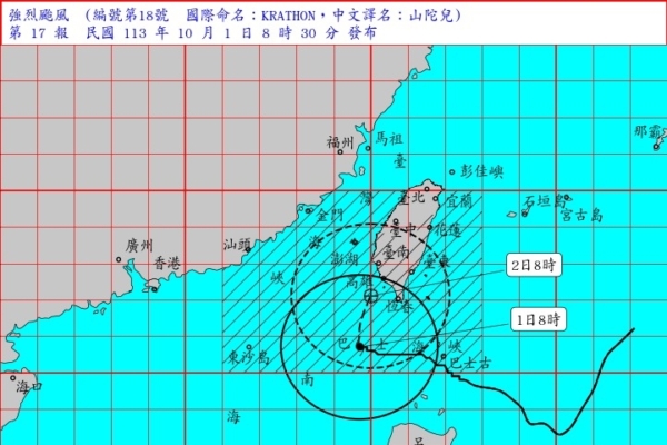
The Taiwan Central Weather Bureau announced today (October 1) that Typhoon Krathon has intensified into a severe typhoon and the land warning has been extended to 9 counties and cities in Taiwan. The public is advised to be vigilant and prepare for the typhoon.
According to the latest typhoon data, Typhoon Krathon (international name KRATHON) has slightly strengthened over the past 3 hours and is currently meandering near the south-southwest coast of Kaohsiung. Its center is slowly moving toward north-northeast direction, with its fierce winds reaching areas including Hengchun Peninsula, Pingtung, Taitung, and Kaohsiung, posing a threat to regions south of Yunlin, Hualien, Taitung, and Penghu.
The severe typhoon’s center as of 9 a.m. today was located at 20.7 degrees north latitude and 119.6 degrees east longitude, approximately 220 kilometers south-southwest of Kaohsiung. It is moving at a speed of 4 to 10 kilometers per hour towards the north-northeast.
Areas under land warning: Yunlin, Chiayi, Tainan, Kaohsiung, Pingtung, Hengchun Peninsula, Hualien, Taitung, and Penghu should be on high alert. Areas under sea warning: Taiwan Strait, northeastern Taiwan waters, southeastern Taiwan waters, Bashi Channel, and Dongsha Islands waters, vessels should be on high alert while navigating or operating.
Today, Taiwan’s coastal and outlying islands are experiencing long waves and significantly higher winds and waves, particularly in the southwest, southeast, and Hengchun Peninsula coastal areas where waves of over 6 meters are likely. People are advised to avoid seaside activities.
Strong wind warnings are in effect: Hengchun Peninsula, Orchid Island, Green Island may experience strong gusts of 10 to 12 on the Beaufort scale. Pingtung, Taitung, Penghu, Kinmen, Matsu areas may experience gusts of 9 to 10, while areas from Kaohsiung northward, Yilan, and coastal areas of Hualien may experience gusts of 8 to 9.
Temperature information: Due to the outer circulation of the typhoon, there is a possibility of localized squalls. During the day, Hsinchu, Miaoli, and Taichung are under a yellow heat advisory with temperatures likely to exceed 36 degrees Celsius.
The Central Weather Bureau warns that as the typhoon approaches today, the tides along Taiwan’s southwestern coast will rise. On the 2nd, Pingtung, Kaohsiung, Tainan, and Chiayi should guard against strong winds and heavy rain, especially coastal areas should be wary of storm surges and seawater inundation.
On September 30 from midnight to 9 a.m. on October 1, there was significant rainfall with Pingtung County’s Dahanshan receiving 336 millimeters, Taitung County’s Lijialin Road recording 332 millimeters, and Chiemi in Hualien County reporting 290 millimeters; strong gusts were observed in Lan Yu at level 12, and level 10 winds hit Orchid Island and Pengjia Islet.
Associate Professor Wu Derong from the Department of Atmospheric Sciences at National Central University expressed that this morning, Typhoon Krathon was visible in the Bashi Channel, with a clear eye and had reached severe typhoon strength.
Wu Derong stated that based on the current forecasted path, today’s rainfall presents two scenarios; significant rainfall affecting the eastern half and a probability of squalls in the northern and central regions. On the 2nd, from south to north, the impact of the storm will gradually expand, with the typhoon center expected to land near southern areas before noon, surpassing the intensity of the Typhoon Selma in 1977 with a destructive force of strong winds and heavy short-term rainfall. Precautions should be taken.
After the typhoon center makes landfall, it is expected to rapidly weaken due to terrain effects. However, precaution against strong winds and heavy rain is still necessary. Starting from the afternoon of the 3rd, the storm circle will gradually move away from south to north, easing the wind and rain in various areas, leading to an improvement in weather conditions.
He emphasized that Typhoon Krathon poses a significant threat to all areas, notably in Pingtung, Taitung, Hualien, and Yilan where rainfall could reach up to 1,300 millimeters in mountainous regions. The southern region should be particularly alert to the “destructive” strong winds and heavy short-term rainfall that the eye wall brings. People across all areas should enhance their preparedness and not take the situation lightly.

