
Taiwanese meteorological experts have stated that the tropical storm “Capricorn” has entered the South China Sea, heading towards the Leizhou Peninsula, and is expected to affect Guangdong and Hainan Island, with no direct impact on Taiwan.
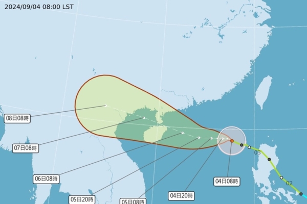
The Central Weather Bureau of Taiwan reported that as of 8 a.m. today (4th), the center of “Capricorn” was located at 18.9 degrees north latitude and 117.7 degrees east longitude, moving at a speed of 10 kilometers per hour to the northwest. The central pressure is 970 hPa, with maximum sustained winds near the center at 33 meters per second and gusts up to 43 meters per second. The radius of gale-force winds extends up to 150 kilometers (140 kilometers to the northwest, 140 kilometers to the northeast, 160 kilometers to the southwest, and 160 kilometers to the southeast), while the radius of storm-force winds reaches 50 kilometers (50 kilometers on each side).
Dr. Wu Derong, an associate professor at the Department of Atmospheric Sciences at National Central University in Taiwan, mentioned in a column today that the European Center for Medium-Range Weather Forecast (ECMWF) and the U.S. model (GFS) simulations indicate the brewing of typhoons east of Taiwan and southwest of Guam around the 10th of the month. The future tracks are subject to changes due to the complex atmospheric conditions, hence continuous monitoring is advised. Whether these systems will affect Taiwan remains uncertain and premature to determine at this stage.
Dr. Wu Derong further pointed out that according to the ECMWF model, there is an increase in atmospheric moisture from the outer bands of “Capricorn” on the 4th and 5th, leading to localized showers in eastern and southern Taiwan, occasional brief showers in the north, and afternoon thunderstorms in mountainous areas in the central and southern regions. With sinking air around “Capricorn,” the western regions remain relatively warm. Today’s temperatures range from 24°C to 37°C in the north, 25°C to 37°C in the central, 25°C to 36°C in the south, and 22°C to 35°C in the east. From the 6th to the 10th, increased atmospheric moisture near Taiwan may cause a slight increase in cloud cover, with intermittent brief showers across different regions. Afternoons may witness localized convection and a likelihood of thunderstorms.
The Central Weather Bureau of Taiwan noted that at 2 a.m. today, Typhoon “Capricorn” was approximately 450 kilometers southwest of Cape Eluanbi, moving westwards towards the Leizhou Peninsula and Hainan Island, without direct impact on Taiwan. However, strong gusts are expected in the coastal areas from New Taipei to Hsinchu, as well as in Kinmen and the Hengchun Peninsula. The eastern coastal regions, including Lanyu and Green Island, may experience heavy swells, cautioning those engaging in sea-related activities.
The Hong Kong Observatory announced this morning that the intensity of Typhoon “Capricorn” has slightly increased in the past few hours. Based on current predictions, wind forces in Hong Kong are projected to rise gradually. Consequently, the Observatory is considering issuing a Strong Wind Signal No. 3 later in the evening, urging citizens to stay away from the shores and refrain from engaging in any water-related activities.