
On October 5th in the afternoon, the center of Typhoon “Medem” made landfall in Zhanjiang, Guangdong, with the maximum wind speed near the center reaching 14 on the Beaufort scale. Seven provinces issued orange warnings for typhoons, heavy rain, and mountain torrents.
The center of Typhoon “Medem” landed on the eastern coast of Xuweng County, Zhanjiang City, Guangdong Province at around 2:50 PM on the 5th, with the maximum wind speed near the center reaching level 14 (42 meters/second, equivalent to a strong typhoon). Due to its impact, regions in Hainan, Guangdong, Guangxi, Yunnan, and other places experienced heavy rainfall and strong winds, leading to localized severe rainstorms.
According to the official media Xinhua News Agency, Hainan’s Haikou and Wenchang were hit by strong winds and heavy rain. By 12 PM on the 5th, nearly 200,000 people in dangerous areas of Hainan had been relocated. Along the west coast of Haikou, the sea surged with high waves, and strong winds accompanied by heavy rain repeatedly battered the coastline. Some roads saw trees uprooted or snapped in half. In the city, roadside barriers and construction site barricades were overturned by strong winds, making it difficult for pedestrians to stand steady.
Reports stated that storm surges combined with astronomical high tides resulted in seawater backflow in low-lying coastal areas like Wenchang Pufeng Town and Haikou Dongzhaigang. Pufeng station recorded a maximum storm surge of 181 centimeters, approaching the red alert tide level, with seawater flooding streets along the coast.
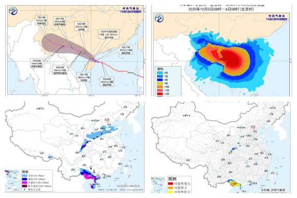
Additionally, at 6 PM on October 5th, the China Meteorological Administration issued orange alerts for the typhoon and heavy rain, with seven provinces expecting heavy to torrential rain.
By 6 PM, the center of “Medem” was located within the jurisdiction of Leizhou City, Guangdong, with the maximum wind speed near the center reaching level 13 (40 meters/second, typhoon level). It is projected that “Medem” will gradually weaken as it moves in a west-northwest direction at a speed of 20-25 kilometers per hour, and is expected to make another landfall along the coasts from Fangchenggang, Guangxi to the border with Vietnam during the night of the 5th (strong tropical storm level, 10-11 levels, 28-30 meters/second), with its intensity continuing to diminish post-landfall.
The warning between 8 PM on October 5th and 8 PM on the 6th indicated that parts of central and western Hainan Island, southwestern Guangdong, southern and western Guangxi, and regions in northeastern Sichuan, southern Shaanxi, central and southern Shanxi, central and southern Hebei, northern Shandong, and northern Henan could experience heavy rain to torrential rain, with some areas facing exceptionally heavy rainfall (250-280 millimeters); meanwhile, regions such as southeastern Tibet, northern Sichuan Basin, southern Shaanxi, central-southern Shanxi, central-southern Hebei, northern Shandong, and northern Henan might witness heavy or torrential rains, with the northern part of the Sichuan Basin seeing localized heavy rainfall (100-130 millimeters).
Simultaneously, the Ministry of Water Resources and China Meteorological Administration jointly issued an orange warning for potential mountain torrents in certain areas, highlighting a higher possibility of flash floods occurring.
Between 8 PM on October 5th and 8 PM on the 6th, regions such as southwestern Guangdong, western and southern Guangxi, northeastern Sichuan, and southern Shaanxi may face a higher risk of mountain torrent disasters (yellow warning), suggesting that certain areas in the southern part of Guangxi could see a significant probability of flash floods (orange warning).